TL;DR
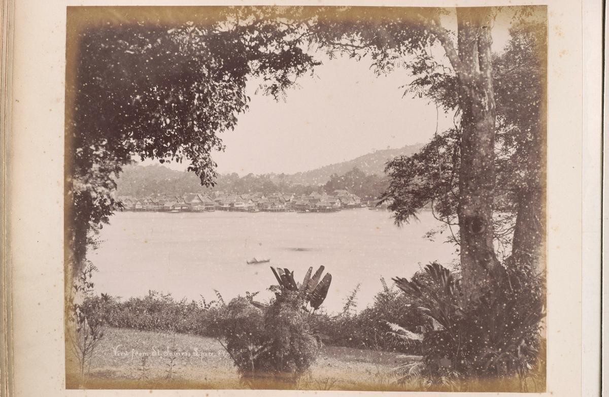
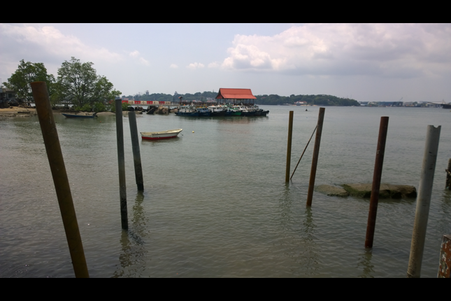
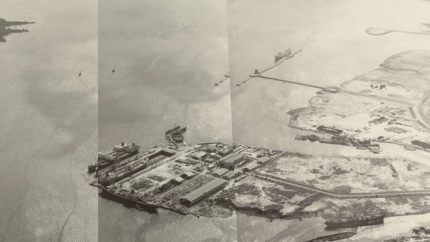
Before Singapore's southwestern islands were transformed into Jurong Island, they bore names like Ayer Merbau, Pesek, and Seraya—each encoding ecological knowledge, spiritual associations, and the maritime histories of communities like the Orang Laut and Bugis. These place names were not merely labels but living archives holding everything from freshwater sources and navigation routes to kinship networks and economic activities, together forming a mnemonic infrastructure. The article asks: What does the name Selat Sembilan actually mean? The answer points to deeper histories than a simple count of nine islands.Fig. 1. Composite aerial photographs of the Jurong offshore islands, including Pulau Samulun, 21 February 1968. Aerial photographs by the British Royal Air Force, 1940s-1970s. Crown copyright, courtesy of the National Archives of Singapore.
Most Singaporeans know Jurong Island as a petrochemical hub, off-limits to the public. Few know the strait that divides it from the mainland—today called Selat Jurong—was once known as Selat Sembilan: the Strait of Nine. Few realise it was once a cluster of islands, each with its name, community, and story. Through oral histories, old maps, and place name etymologies, this article asks what "Sembilan" could mean.
The Strait of Nine
"Selat Sembilan atau kini dikenali sebagai Selat Jurong, yang memisahkan pulau-pulau itu dengan Singapura, diberi nama sempena sembilan buah pulau yang terletak berdekatan antara satu sama lain di situ – iaitu Pulau-pulau Ayer Merbau, Ayer Chawan, Sakra, Bakau, Seraya, Merlimau, Meskol, Pesek dan Mesemut Laut."
"Selat Sembilan, now known as Selat Jurong, which separates those islands from mainland Singapore, was named after the nine islands clustered closely together in that area—namely Pulau Ayer Merbau, Ayer Chawan, Sakra, Bakau, Seraya, Merlimau, Meskol, Pesek, and Mesemut Laut."
— Encik Ismail bin Mohd Ali, former penghulu (village head) of Pulau Ayer Merbau and surrounding islands, as interviewed by journalist Zainal Jamari in Berita Harian, 30 August 1981.[1]
What is Selat Sembilan? Encik Ismail was speaking in 1981, less than a decade after he was relocated from these offshore islands to the mainland (Fig. 1). His answer is the obvious one: the strait was named for nine islands. But on a 1939 British War Office map, one can count fourteen islands beyond the strait. Pulau Seburus (Luar and Dalam), Pulau Buaya, Pulau Damar (Laut and Darat)—none of these appears in Encik Ismail's enumeration.
To understand that discrepancy, this article looks at place names as historical evidence. They record freshwater sources, tree species, trade routes, and respected elders—each name a trace of how communities understood and used their environment.
What’s Behind Sembilan? Samulun/Semulun?
The earliest known rendering of the strait's name appears on a hydrographic map compiled around 1820 under Lieutenant-Colonel William Farquhar (Fig. 2): "P. Sinbolan." By 1851, J.R. Logan's geological map (Fig. 3) labels the waterway "Silat Sambulan." The name continued to shift: "Samboolan," "Samulun," "Semulun"—each variant a different colonial attempt to transcribe a name that was not originally written down.
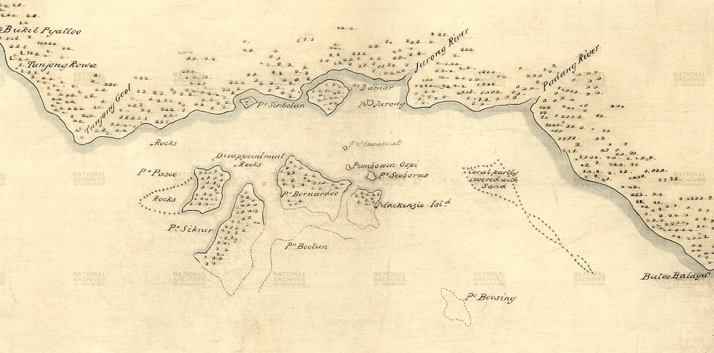 Fig. 2. Hydrographic map of Singapore and adjacent islands, c. 1820, compiled under Lieutenant-Colonel William Farquhar. Pre-standardised spellings include "P. Pasee" (Pulau Pesek), "P. Sikrar" (Pulau Ayer Chawan), "P. Bootun" (Pulau Ayer Merbau), "P. Bernardo" (Pulau Merlimau), "Mackenzie Isl.d" (Pulau Seraya), and "P. Sinbolan" (Pulau Samulun). CO700 Straits Settlements No. 4, Accession No. D2019_000020_TNA. Courtesy of The National Archives (UK) and the National Archives of Singapore.
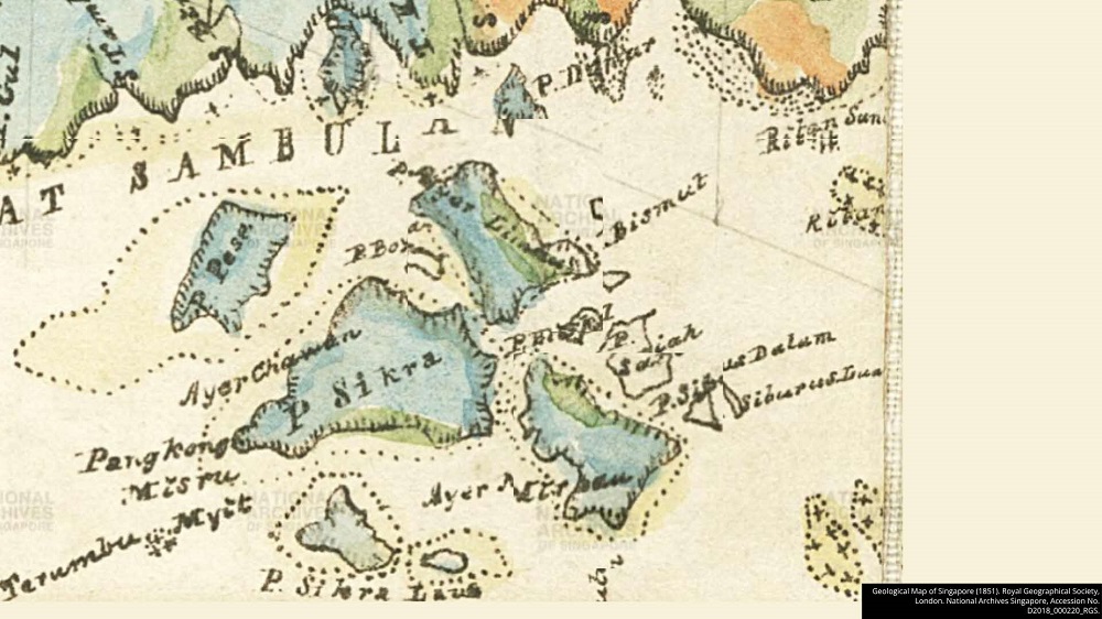 Fig. 3. Geological map of southern Singapore, 1851, compiled by J. R. Logan for the Royal Geographical Society. Early place name variants include "Pess" (Pulau Pesek), "Sikra" (Pulau Sakra), "Boyan" (Pulau Seraya), and "Ayer Chawan" (Pulau Ayer Chawan); the waterway is labelled "Silat Sambulan." Accession No. D2018_000220_RGS. Courtesy of the National Archives of Singapore.
By the 1920s, maps had begun distinguishing Selat Semulun—the narrower waterway between Samulun Island and the mainland—from the broader Selat Sembilan.[2] Two names, related but distinct, for adjacent waters. The separation suggests that "Semulun" and "Sembilan" were understood, at some point, as different, not simply as variant spellings of the same word.
By 1923, a British War Office survey map of Tuas and the Jurong offshore islands (Fig. 4) had standardised the place names across the region, replacing earlier colonial variants such as "Bernardo" (for Pulau Merlimau) and "Sikrar" (for Pulau Ayer Chawan) with the Malay names now recognised. It was in this period that "Sembilan"—nine—became the settled rendering. The 1939 War Office map (Fig. 5) labelled the strait "Selat Sembilan". But the phonological question remains: is "Sembilan" what the name always meant, or is it what colonial administrators heard?
References to Linschoten's 1595 Reysgeschrift had already mentioned Pulau Sembilan in the region.[3] Whether his pilots were transcribing an indigenous name or simply using a Malay numeral, the name was already in circulation more than two centuries before the 1923 standardisation.
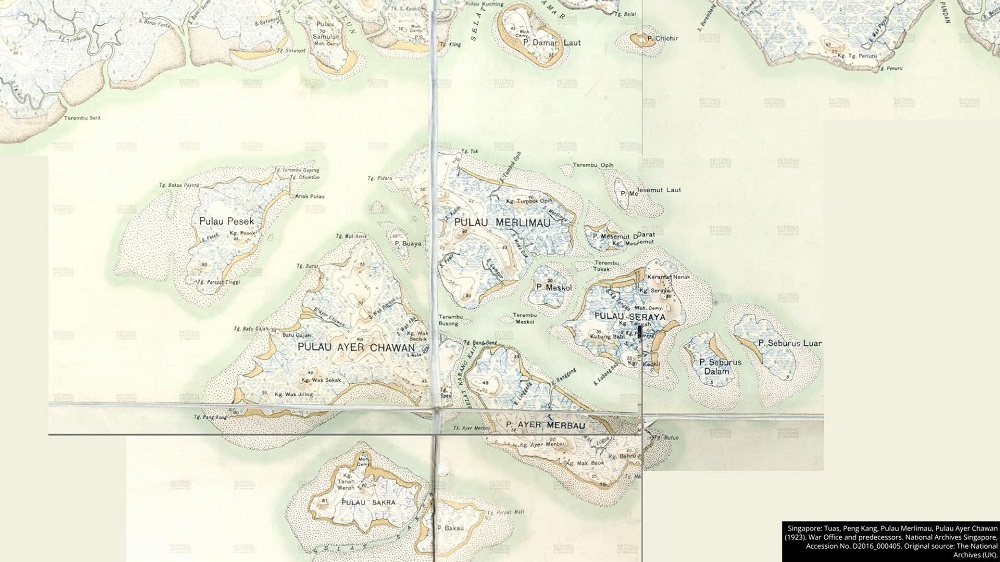 Fig. 4. Survey map of Tuas, Peng Kang, and the Jurong offshore islands, British War Office, 1923. Reflects the formal adoption of standardised place names, replacing earlier variants such as "Bernardo" and "Sikrar." WO 78/5364 (pt10), Accession No. D2016_000405. Courtesy of The National Archives (UK) and the National Archives of Singapore.
 Fig. 5. Topographic map of southern Singapore and adjacent islands, British War Office, 1939. Depicts the pre-reclamation Jurong landscape, including Pulau Ayer Chawan, Pulau Sakra, Pulau Pesek, Pulau Merlimau, and Pulau Seraya. War Office, Geographical Section, General Staff, No. 3772 (Sheet 3L/11d, Second Edition), Accession No. TM001047. Courtesy of the Singapore Land Authority and the National Archives of Singapore.
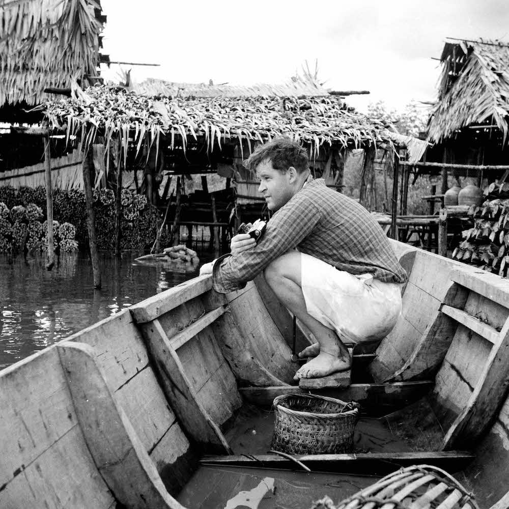
The Orang Laut
The Orang Laut—including subgroups such as the Seletar, Selat, and possibly the Semulun—likely inhabited the islands now known as Jurong Island well before 1819.[4] The Orang Seletar lived along rivers and coastal mangroves, while the Orang Selat were known for their maritime mobility along the southern straits.[5]
H.T. Haughton, in 1889, suggested that "Sěmúlun" may instead refer to an Orang Laut subgroup.[6] The phonetic shifts between "Samboolan" and "Samulun" may also reflect dialectal patterns. In the Kon dialect spoken by Orang Laut communities, bilabial clusters like mb are often reduced (e.g. ambik becomes amek), a linguistic trait shared with vernacular Malay. The later standardised Malay term Sembilan may thus be a retrospective reinterpretation of an older Orang Laut phonology.[7] European mariners, including those recorded in Jan Huyghen van Linschoten's 1595 Reysgeschrift, would have relied on these communities to traverse the shoals of Selat Jurong.[8] That they encountered the name at all suggests the Orang Laut were its likely source.
The name Semulun was not unique to this cluster of islands. A coastal settlement in Sabah, known today as Sembulan Lama, was formerly inhabited by Brunei, Bajau, and Idaan communities. It was once known as Simpulan—a term associated with knots or alliances. Oral traditions associate this name with the Sama-Bajau, and possibly with fish such as bulan-bulan, which are linked to lunar cycles. Some accounts suggest that Sembulan and its variants were used by Orang Laut or Harimau Laut, who once ranged across southern Singapore.[9] The recurrence of this name-cluster across Borneo and the southern Straits points to an Austronesian toponymic pattern transmitted through seafaring networks. If the name travelled with seafaring communities across the Straits, it is more likely to encode a people than a number.
The island place names of Selat Sembilan carry further traces of Orang Laut presence. Pulau Meskol, for instance, may derive from sekol (a coconut-shell water vessel), with mi- as a dialectal Orang Laut affix.[10] Pulau Seraya, named after the seraya tree (Shorea curtisii), was favoured for boatbuilding by the Orang Seletar, who used its timber to build pau kajang.[11] Oral accounts suggest that Orang Selat families had settled on Seraya from surrounding islands—including Pulau Damar and Telok Saga—before the 20th century.[12]
What the Names Encode
"Meskipun ia cetek, tetapi air di perigi itu tidak pernah kering dan di musim kemarau, para penduduk di pulau-pulau yang berdekatan akan datang ke situ untuk mengambil air," tambah Encik Ismail lagi.
"Even though it was shallow, the well never ran dry, and during the dry season, residents from nearby islands would come there to collect water," added Mr Ismail. [13]
The prefix Sungai (river) marks water sources—e.g. Sungai Merlimau, Sungai Ayer Chawan—while Tanjong (cape/headland) names signal lookout points or coastal features—e.g. Tanjong Ayer Merbau, Tanjong Mak Boak. The recurring prefix Ayer (water) highlights islands with freshwater access, a crucial criterion for long-term habitation in offshore settings. Names like Ayer Rajah and Ayer Gemuroh on the mainland similarly evoke associations with water, waves, and coastal terrain.
Kampong names can also honour individuals, particularly elders or religious figures. Names like Wak Benchik, Wak Sekak, and Wak Jiling use the Wak honorific, paralleling other sites like Kampong Wak Sumang in Punggol and Kampong Wak Tanjong in Geylang. Additionally, some names offer clues about past land use. Kampong Kubang Babi (literally "pig wallow") on Pulau Seraya is not mentioned in oral accounts but may hint at pig-rearing activities, possibly linked to Chinese communities. Kampong Jawa signals Javanese presence, while Kampong Bahru likely denotes resettlement or expansion.
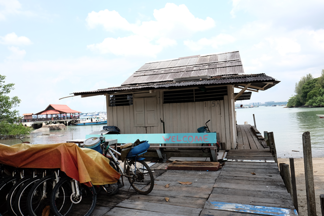
While some kampongs had disappeared by the early 20th century, their names continued to appear on maps until the 1960s. Others—such as Kampong Gate Lima, Kampong Geylang, and Kampong Jawa on Pulau Seraya—are absent from maps but persist in the oral memories of former islanders.[14]
The Bugis and Later Settlers
"Encik Ismail berkata bahawa suatu masa dulu, ramai orang Bugis yang tinggal di situ [Pulau Ayer Chawan] dan menanam nenas. Suatu hari sedang mereka menyangkul, mereka terjumpa banyak cawan kaca di ladang nenas mereka. Dari mana atau bagaimana cawan-cawan itu boleh berada di pulau itu, tidak pula diketahui."
Mr Ismail said that some time ago, many Bugis people lived there [Pulau Ayer Chawan] and planted pineapples. One day, while they were digging, they discovered many glass cups in their pineapple field. The origin of those cups on the island remains unknown. [15]
According to Ismail bin Mohd Ali, Pulau Ayer Chawan had a known Bugis presence. Additionally, the name Pulau Pesek may derive from the Bugis word for holed coins. Bugis communities were historically present across the southwestern islands. Originating from Sulawesi, the Bugis established extensive maritime networks by the 18th and 19th centuries, often settling in the Johor-Riau region. Their mobility and maritime expertise made offshore islands suitable for settlement.
Hamzah Haji Hussein, Pulau Seraya’s final penghulu, noted that Pulau Merlimau, Ayer Chawan, and Seraya attracted Bugis settlers due to good fishing grounds. [16] Pulau Seraya, for example, was divided into Seraya Besar and Seraya Kecil. The latter was initially home to two or three Bugis families, with Bugis-style stilt houses common along the coast. However, by 1961, Seraya Kecil was unoccupied. [17]
Over these older Orang Laut and Bugis presences, later settlers added further layers. On Pulau Seraya, Hamzah Haji Hussein recalled that residents from Bintan and Java, many of whom were described as orang beragama (religiously inclined), had settled there. [18] His son, Ali bin Hamzah, added that their family originated from Bintan. [19] Meanwhile, a Teochew settler, Xu Xifan, recounted migrating to Pulau Merlimau after World War II to cultivate fruit trees on land owned by a relative. [20]
Maritime Malays, Bintanese and Javanese migrants, and Chinese smallholders lived alongside one another. The oral histories from NAS and field interviews document this mid-20th-century picture well.
Conclusion: What Sembilan Might Really Mean
In the case of Selat Jurong—or Selat Sembilan, as it was once known—place names outlast the places themselves. They record where water was found, which trees were felled, and who settled where. The evidence assembled here does not prove that "Sembilan" is a mistranscription of an Orang Laut name. What it does show is that the standard explanation—nine islands, hence the name—does not hold up: there were fourteen islands, the name was unstable across two centuries of cartography, and the earliest variants do not obviously mean "nine" in any language. Haughton's 1889 suggestion that "Sěmúlun" may refer to an Orang Laut subgroup remains unverified but is not implausible.
The transformation of Jurong into a petrochemical hub began long before the 1970s reclamation. Even in the colonial period, representations of the islands were filtered through extractive and administrative lenses—maps and censuses that rarely captured local terms or the lived meanings of these terms. Reading colonial records against oral histories and vernacular accounts recovers what administrative maps left out.
This article has traced how island place names carry linguistic, ecological, and social histories simultaneously. Reading Jurong Island through its place names makes visible whose knowledge was encoded in the landscape, and whose was subsequently erased. Doing so recovers the histories of the Orang Laut, Bugis, Malay, and Chinese communities who inhabited these islands. The next time you pass Jurong on the highway, spare a thought for the vanished coast beneath it. Somewhere under the tarmac and pipelines lie the memories of Selat Sembilan. Their names may be gone from the signs and maps, but they can still be remembered.
The following table summarises the place names and etymologies of the various islands that now make up Jurong Island, based on information gathered from published writings, archival documents, and oral history accounts:
|
Island Name |
Etymology of Name |
Names of Settlements and Features |
|
Ayer Chawan |
Ayer: Suggestive of wells. Possibly from Kembang Semangkuk (Scaphium longiflorum), whose leaves resemble cups. Name may also be linked to the presence of numerous cups or “chawan.” |
Settlements:Kg Wak Benchik, Kg Wak Sekak, Kg Wak Jiling |
|
Ayer Merbau |
Ayer: Suggestive of wells.
|
Settlements:Kg Ayer Merbau, Kg Bahru, Kg Mak Boak |
|
Ayer Merlimau (Ayer Limau) |
Merlimau: From “limau” (lime) with the prefix ‘mer’ suggesting similarity but not identity to lime. Also linked to Gelonium spp. (false lime). |
Settlements:Kg Tumbok Opih, Kg Ayer Limau, Kg Limau Manis |
|
Bakau |
Bakau: Refers to mangrove trees common in coastal areas found on the island. |
(No listed settlements) Geographical Features:Tg Perpat Mati |
|
Buaya |
From its crocodile-head shape; Visual toponymy common in island naming. |
|
|
Mesemut (Darat, Laut) |
Mesemut: Derived from "semut" (ant), though the name’s deeper origin is not extensively detailed here. |
(No listed settlements or features) |
|
Meskol |
Meskol: From "miskol" (Orang Laut origin), referring to a large coconut-shell water vessel. The root form is "Sekol"; “Mi” is an Orang Laut linguistic affix. As compared to Tg Terembu Gayong (on Pulau Pesek). The "Gayong" is shallower and is the half shell. |
(No listed settlements or features) |
|
Pesek (Pesek Kechil) |
Pesek: Named after lively gatherings where sailors danced to violin music (“mengesek biola”); Another version:Pesek(Bugis) coins with holes in the middle. |
Settlements:Kg Pesek |
|
Sakra |
Sakra: Possibly from “kera” (monkeys) abundant on the island. From Shikra bird (Tachyspiza badia), a trained raptor. |
Settlements:Kg Tanah Merah, Muslim Cemetery Geographical Features:Selat Sakra |
|
Seraya |
Seraya: Named for Seraya trees (Shorea curtisii), a type of dipterocarp known for its two-winged fruits that are dispersed by the wind. This tree produces a light hardwood with fine grain and a medium to deep red heartwood, commonly referred to as dark red meranti. Historically used by Orang Seletar to build pau kajang. |
Settlements: Kg Tengah, Kg Seraya, Kg Pulau Kecil, Kg Kubang Babi, Keramat Nenak, Muslim Cemetery Geographical Features: Sg Pulau Seraya, Sg Kg Tengah, Sg Kubang Babi |
|
Seburus (Dalam, Luar) |
Seburus: Named for a fruit-bearing tree (Urophyllum trifurcum) found in mangrove swamp environments. |
(No listed settlements or features) |
|
Semulun (Sinbolu, Sumboolan, Sambulan, Samulun |
Semulun: Possibly derived from an Orang Laut tribe name; from variations of "Sembilan" (Malay for “nine”). |
Settlements: Kg Semulun, Muslim Cemetery Geographical Features:Pulau Semulun, Pulau Sembilan |
This research was supported by the National Heritage Board’s Heritage Research Grant.
Notes
[2] War Office, Geographical Section, General Staff, Johore and Singapore, Sheet 3L/11d, 2nd ed., No. 3772 (London: War Office, 1928; map dated 1939), Accession Number TM001047, Image No. 20120001657-0001, courtesy of the National Archives of Singapore and Singapore Land Authority; Survey Department, Singapore, Singapore [Topographic Map of Jurong District], Accession Number M2016_000175_SD, Series L 802, Sheet 5 Ref No. 111-1964 (Kuala Lumpur: Director of National Mapping, Malaysia on behalf of the Chief Surveyor, Singapore, 1966); Singapore Land Authority, Singapore. Jurong, Accession Number TM001008 (surveyed 1972–1973; Singapore: Mapping Branch, Ministry of Defence); Singapore Land Authority, Singapore. Jurong, Accession Number TM001070 (surveyed 1978; Singapore: Mapping Branch, Ministry of Defence).
[3] Jan Huyghen van Linschoten, Itinerario, Voyage ofte Schipvaert van Jan Huygen van Linschoten naer Oost ofte Portugaels Indien, 1579–1592, ed. H. Kern, vol. 1, chap. 20 (The Hague: Martinus Nijhoff, 1910–1939).
[4] The Orang Laut are sea- and river-based nomads who have inhabited Singapore and other parts of Southeast Asia since at least the 16th century, with tribes such as Orang Suku Biduanda Kallang, Orang Suku Galang, Orang Suku Gelam, Orang Suku Seletar, and Orang Suku Selat residing in Singapore before 1819. These tribes lived in areas such as the Kallang River, Geylang, Kampong Glam, Seletar River, and the Keppel Harbour region, with their settlements documented on archival maps. For more, see C.A. Gibson-Hill, The Sampan Panjang and the Orang Laut (Singapore: Royal Asiatic Society, 1952); C.A. Gibson-Hill, "The Orang Laut of the Singapore River and the Sampan Panjang," Journal of the Malaysian Branch of the Royal Asiatic Society 25 (1952): 161–174; David E. Sopher, The Sea Nomads: A Study of the Maritime Boat People of Southeast Asia (Singapore: National Museum Singapore, 1977); Muhammad Ali, "Singapore's Orang Seletar, Orang Kallang, and Orang Selat: The Last Settlements," in Tribal Communities in the Malay World: Historical, Cultural and Social Perspectives, ed. Geoffrey Benjamin and Cynthia Chou (Singapore: ISEAS Publishing, 2002), 273–292; Leonard Y. Andaya, "The Orang Laut and the Malayu," in Leaves of the Same Tree: Trade and Ethnicity in the Straits of Melaka (Honolulu, HI: University of Hawai'i Press, 2008), 173–201; Cynthia Chou, The Orang Suku Laut of Riau, Indonesia: The Inalienable Gift of Territory (New York, NY: Routledge, 2010).
[5] Mariam Ali, "Singapore's Orang Seletar, Orang Kallang, and Orang Selat: The Last Settlements," in Tribal Communities in the Malay World: Historical, Cultural and Social Perspectives, ed. Geoffrey Benjamin and Cynthia Chou (Singapore: ISEAS Publishing, 2002), 273–292.
[6] William L. Gibson, Complete Catalog of Keramat in Singapore, Lee Kong Chian Research Fellowship (Singapore: National Library Board, 2022), 429; H.T. Haughton, "Notes on Names of Places in the Island of Singapore and Its Vicinity," Journal of the Straits Branch of the Royal Asiatic Society 20 (1889): 80.
[7] Tan Zhi Xuan, personal communication with the author, May 29, 2025.
[8] Jan Huyghen van Linschoten, Itinerario, Voyage ofte Schipvaert van Jan Huygen van Linschoten naer Oost ofte Portugaels Indien, 1579–1592, ed. H. Kern, vol. 1, chap. 20 (The Hague: Martinus Nijhoff, 1910–1939).
[9] Jeffri Mohd Asi, Simbulan 1788 – Sejarah Sembulan Lama: Kajian Awal, Catatan Lisan dan Tarsilah Keluarga Besar, Borneo History 57 (2016), https://borneohistory57.blogspot.com/2016/11/sejarah-awal-simbulan_13.html. See especially Section 4, "Asal Usul Nama Simbulan atau Sembulan Lama."
[10] Zainal Jamari, "Asal Usul Nama Pulau-Pulau di Selatan," Berita Harian, August 30, 1981, 3.
[11] Amir Ahmad and Hamid Mohd Isa, "The Influence of Environmental Adaptation on Orang Seletar Cultures," 7th International Seminar on Ecology, Human Habitat and Environmental Change in the Malay World, University of Riau, January 27, 2015; H.T. Haughton, "Notes on Names of Places in the Island of Singapore and Its Vicinity," Journal of the Straits Branch of the Royal Asiatic Society 20 (1889): 79.
[12] Hamzah Haji Hussein, Communities of Singapore (Part 3), interview by Mohd Yussoff Ahmad, Oral History Centre, Accession No. 000900, National Archives of Singapore; "Undiscovered Singapore," The Singapore Free Press and Mercantile Advertiser, January 9, 1931, 1.
[13] Zainal Jamari, "Asal Usul Nama Pulau-Pulau di Selatan," Berita Harian, August 30, 1981, 3.
[14] Ali bin Hamzah, interview by Hadi Osni, August 27, 2024.
[15] Zainal Jamari, "Asal Usul Nama Pulau-Pulau di Selatan," Berita Harian, August 30, 1981, 3.
[16] Hamzah Haji Hussein, Communities of Singapore (Part 3), interview by Mohd Yussoff Ahmad, Oral History Centre, Accession No. 000900, National Archives of Singapore.
[17] The Singapore Free Press, "Our Island Neighbours," November 10, 1961, 6.
[18] Hamzah Haji Hussein, Communities of Singapore (Part 3), interview by Mohd Yussoff Ahmad, Oral History Centre, Accession No. 000900, National Archives of Singapore.
[19] Ali bin Hamzah, interview by Hadi Osni, August 27, 2024.
[20] Xiu Jinglong (修景隆), "旧祖里岛女 [Old Pulau Jurong Woman]," Lianhe Zaobao, July 16, 2023.