
Pulau Ubin Cultural Mapping Project
“Rustic”, “Nature”, “in danger”; these are popular words people use to describe Pulau Ubin, an island off Singapore that appears to be in decline. The National Heritage Board (NHB) commissioned a Cultural Mapping Project to study the island’s community and social network. The year-long project, which started in April 2015, documents the well-loved island’s living heritage through oral history accounts and lifestyles of its residents and former residents. The project took place from April 2015 to April 2016 and it tells us that Ubin is anything but in danger of being in decline.
The findings from the Cultural Mapping Project challenges this and informs us that Pulau Ubin’s kampong-centred social network is a thriving one, and has evolved to extend beyond residents living on the island, to non-residents and regular visitors. The kampung lifestyle endures on Pulau Ubin and the island’s unique cultural events like the week-long Tua Pek Kong festival continues to strengthen local bonds of friendship. The festival, which features spirit medium processions, rituals, opera, getai performances and lion dances, also attracts thousands of visitors to the island offering a platform for the renewal and expansion of the social network that spans from Ubin to Singapore Island.
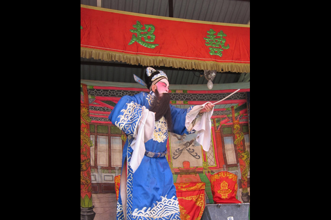 Opera Singer at Tua Pek Kong festival
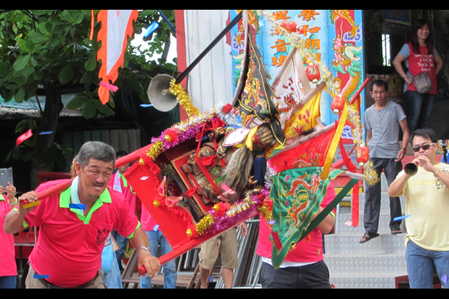 Sedan chair carrying Tua Pek Kong at Tua Pek Kong Festival 2015 on Pulau Ubin
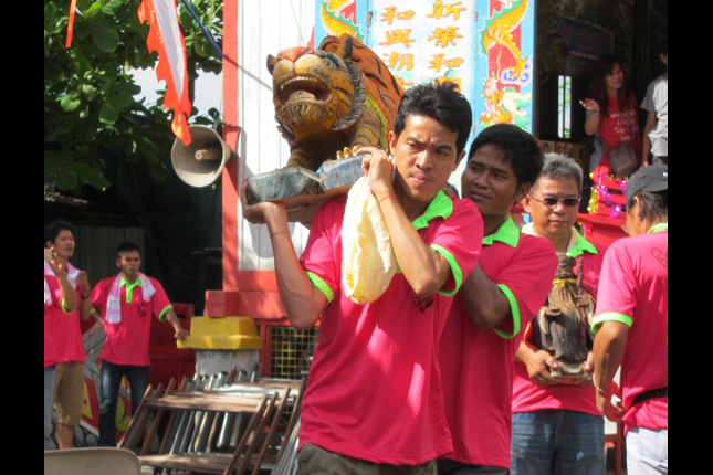 Tiger God brought down from hill at Tua Pek Kong Festival 2015 on Pulau Ubin
Visitors to Pulau Ubin are drawn into the network by their diverse connections with the island, whether through work, family-run businesses, informal apprenticeships, religious activities, or fitness and leisure. The constant flow of non-residents to the island, and their induction into the existing network, reflects an evolving kampong community.
As part of the Pulau Ubin Cultural Mapping Project, NHB has produced a 25-minute documentary titled “Life on Ubin”, which presents the memories and experiences of current and former residents of Pulau Ubin.
More About Pulau Ubin
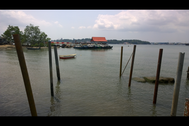
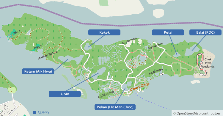
Pulau Ubin lies on the Straits of Johor off the North-eastern coast of mainland Singapore, separated by Serangoon Harbour. It was known as Granite Island ("Chieo Suar" 石山), as granite from the island was used to make floor tiles or jubin in Malay. The island's name derived from a shortened or corrupted form of jubin to Ubin.
This boomerang shaped island has an area of 10.2 sq km. The island is 8km long and about 1.3-1.7 km wide. This is Singapore's second largest offshore island and was the result of amalgamating five smaller islands as the river separated them was dammed for prawn farming.
During the 16th-17th century, Pulau Ubin came under the influence of the Johor-Riaus Empire and the earliest inhabitants were the Orang Laut and indigenous Malay with Bugis and Javanese origins.
During the mid 1840s, the Chinese began settling in Pulau Ubin and started to quarry granite. In the 1850s, Government quarries were established and convicts were deployed to quarry granite for the construction of Horsburgh Lighthouse on Pedra Branca (1851), Raffles Lighthouse (1855), the Causeway (1923), Pearl's Hill Reservoir (1903), Fort Canning (1858), Fort Canning Reservoir (1926), Fort Fullerton Expansion and Singapore Harbour (1913).
During the 1880s, Encik Endun Senin initiated a major migration project to settle inhabitants from Kallang River area to Pulau Ubin. About 50 families settled around the South-eastern coast of the island at Kampong (Kg) Durian, Kg Melayu, Kg Sungei Durian and Kg Surau. Most of them were fishermen. Other Malay Kampongs included Kg Noordin, Kg Bahru, Kg Mamam, and Kg Petai at the Northern coast and Kg Chek Jawa at the Eastern tip of the island.
Pulau Ubin is also called Ban-Gang (半港) by the island's Chinese community. The island's former Chinese residents were Hokkien, Teochew, Hakka, Cantonese and Hainanese. The Chinese community was concentrated on the Central and Western parts of the island.
Other colloquial names for places/sites on the island include the village centre at Kangkar ((港脚, Kg China), Xingang (新港, where Wei Tuo Fa Gong Temple stand), Dao Diao Gang (大条港) Ji Diao Gang (二条港), Ong Lay Sua (黄梨山 Bukit Nanas) and Kopi Sua (咖啡山).
Besides the Government quarries, it was reported that there were 10 other quarries operated by 9 different companies in the 1930s. However by the 1950s, five quarries had been abandoned, and granite mining activities ceased in the 1960s. The last operational quarry on the island was closed in 1999. In Apr 2007, the government announced that the Kekek Quarry will be reopened for limited quarrying.
Between the 1950s and early 1970s, the population of the island was about 2,000. Three quarters of the residents were Chinese, one quarter Malay and the rest were Indian. In the 1970s, the number began to decease after the granite quarries started to close down. There were about 1,000 residents in 1987, 400 in the mid 1990s, 139 in 2001 and only 38 residents in 24 households left in 2012.
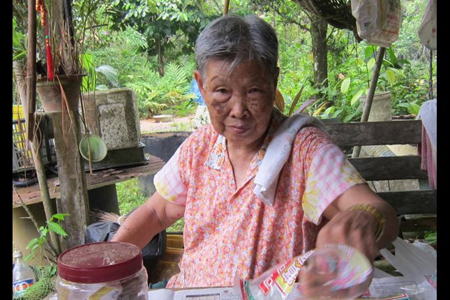 Ubin Resident Lee Hua
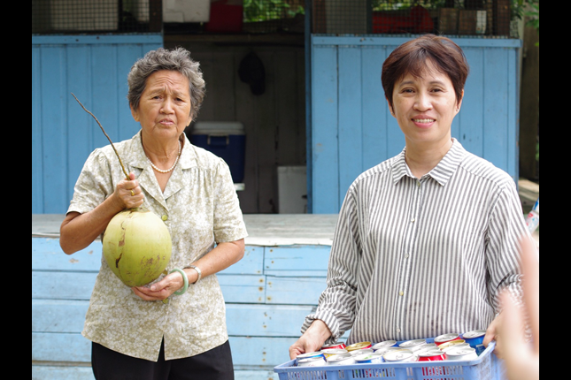 Mdm Ong Ang Kui & Ivy Choo who run Ah ma Drinks stall
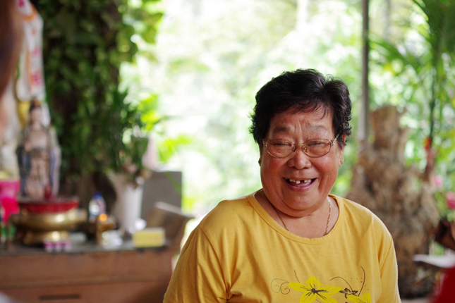 Mdm Ong Siew Fong - Custodian of Wei Tuo Temple on Pulau Ubin
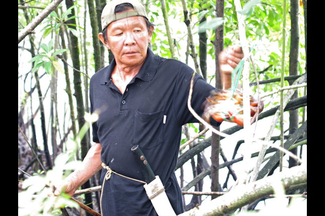 Mr Quek Kim Kiang - Crab Catcher
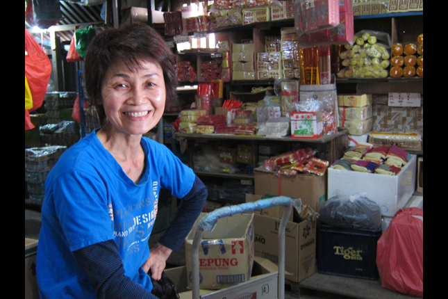 Ms Chew Loke Kuan who runs Shop No 49a on Pulau Ubin
There used to be several large rubber and other cash crop plantations on Pulau Ubin. Among them, the Pulau Ubin Estate was the largest. It was established by F. St. George Caulfield who was Acting Colonial Engineer in 1900 and the Director of Public Works in 1903. The estate was situated at the western tip of the island (the site of the present-day Outward Bound School). Other estates belonged to Ong Swee Chew, Wee Cheng Soon, Lam Hong, Sin Watt, Sam Heng, Ong Ting Lye and Henry Daniel Chopard.
Crop cultivation was the main commercial activity on Pulau Ubin. The main types of crops included coffee, nutmeg, pineapple, coconut, durian, tobacco and rubber. These were found mostly at the Eastern part of the island at the turn of the last century. Rubber tapping on Pulau Ubin officially ceased in the 1980s.
Other island residents were involved in occupations such as prawn farming, fishing (including kelong fish rearing) and poultry rearing. Learn more about the boat operators of Pulau Ubin in this video.
Watch: The Boat Operators of Pulau Ubin
Examples of sites of heritage value found on the island include:
- The main jetty was first built by the Japanese between 1942 and 1943, rebuilt in 1965 and opened by then Minister of Education in 1965, and shifted to a new jetty in 1978 which was upgraded in 1994.
- The former Bin Kiang School (敏江学校,1952-1985) once had about 400 students and 11 teachers. Prior to its establishment, it existed as an informal school run by the Quarry Workers Union. The Street Opera (Wayang) stage in front of the jetty doubled up as a classroom.
- Former Maternity and Child Health Clinic (established in 1957-1987).
- Former Pulau Ubin Community Centre (1961-2003).
- Former Kampung Melayu Malay School (1956-late 1970s).
- Places of Worship
- Tua Peh Kong temple (佛山亭,estb. 1869) is located in Kangkar, at the south-eastern section of central Pulau Ubin. The main temple is located on a granite hill, while its subsidiary temple with a wayang stage is located near the jetty. Chinese opera is performed on three occasions annually: on the birthday of the deity in the 4th month of the lunar calendar, during the Hungry Ghost Festival and during Vesak Day celebrations.
- The former Mazu (Ma Chor) temple (半港天后圣母宫) was located near the jetty of Outward Bound Singapore Camp 2. This temple has been deconsecrated and moved to Sengkang in the 1990s.
- Wei Tuo Fa Gong Temple (新港韦陀法宫) is located near Jelutong Bridge.
- Qiao Tuo Da Bo Gong (桥头大伯公) and Na Du Gong shrine (拿督公) along Jalan Endut Senin after Jelutong Bridge.
- Na Du Gu Niang (拿督姑娘) shrine, established in 1914, is located adjacent to the Aik Hwa Granite Quarry. It is unique as it is a local Chinese shrine dedicated to a German girl. The young girl's stayed with her parents on the island in 1913 as her father was the manager of a coffee plantation. When WW I broke out in 1914, she accidentally fell to her death in a granite quarry while trying to escape from British authorities. After the war, people built a shrine and began to pray to her for blessings. Her grave was exhumed to make way for quarry excavation work in 1974.
- Jalan Wat Siam at Kekek Quarry was named after a Thai Buddhist temple (Shi Shan Fo Si Temple, 石山佛寺, estb 1986). It was relocated to Sengkang in 2007.
- The surau or Muslim Prayer Hall in Malay located near Kg Malayu.
- No. 1 Pulau Ubin, located at the eastern tip of Pulau Island, is built in the 1930s. The former residence is currently used as a visitors centre, and is believed to be Singapore's last authentic Tudor-style house with a fireplace.
- Tradition kampong houses are located in the Eastern and Central parts of the island. These are occupied by Malay and Chinese residents respectively.
- Burial Sites :
- There are three Chinese cemeteries on the island:
- Kg Bukit Coffee Chinese Cemetery located just before the Thai temple where 35 Cantonese residents were buried in the 1970s.
- The second cemetery is located behind the current police post.
- The third and largest one containing 70 burials is located at Jalan Batu Ubin, opposite the main gate to Ho Man Choo Granite Quarry. Residents are no longer allowed to bury the dead in the three cemeteries.
- There are also at least three Malay cemeteries on the island including Kg Sg Durian, Kg Malayu, Kg Sarau, Kg Chek Jawa and at Tg Chek Jawa.
Pulau Ubin was also the island to which ex-political detainees were exiled and they included Lee Tee Tong (Lee Tse Tong), the former treasurer of the defunct Singapore Bus Workers' Union and former Barisan Socialis MP of Bukit Timah (GE 1963) and Said Zahari, the former editor of the Malay-language newspaper, Utusan Melayu.
In the 1958 Master Plan, Pulau Ubin was designated for "Mineral Workings" and "Fisheries Reserves" uses. The status was changed to "Rural" and "Unplanned" in the 1977 and 1980 Master Plan respectively.
In URA's Revised Concept Plan 1991, the island was earmarked for industrial and infrastructure development. However, its planning status has been reviewed in 2003 after the shelving of the Tanjong Chek Jawa reclamation project. The island has since been designated as a recreational area where its rustic nature was retained.

Today, the island offers a unique experience to visitors and is a popular destination for heritage, nature and adventure lovers. An estimated 300,000 visitors go to Pulau Ubin each year.
The majority of Pulau Ubin is currently managed by NParks. According to NParks, the island attracts more than 300,000 visitors annually.
A project by National Heritage Board.