Text by Clement Liew
MuseSG Volume 10 Issue 1 – June 2017
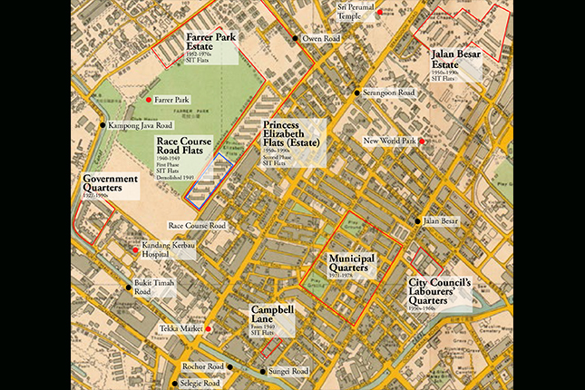
There are many stories of Serangoon Road which tell of the people, trades and festivities that make Little India an interesting and exciting place for locals and tourists to visit. Yet, there’s still plenty waiting to be discovered. Some of the following accounts will not only shed light on some of the realities that we see along the streets of Serangoon Road today, but also enrich our knowledge of how Little India came to be. One of these historical nuggets is the district’s forgotten urban heritage which is an integral part of Singapore’s urban redevelopment and nation building story. It was during the 1920s that government quarters were built within parts of Little India to form small housing estates. It was around these population clusters that various ethnic communities began to put down their roots and create places which they would later call home.
Homes for Government Workers – The Genesis of a Community
Today, there are several abandoned long blocks of terrace houses along Hindoo Road. They were once part of a cluster of residences that the government used to house labourers under its employ, many of whom were Indians. Starting from around 1920, the government started building such quarters in the area bounded by Upper Weld Road, Jalan Besar, Rowell Road and Kampong Kapor Road.
 These terrace houses were built in the 1920s at the junction of Chitty and Kampong Kapor Roads, c. 1966.
Courtesy of Urban Redevelopment Board.
Looking at the layout of this area, it is clear that a planned housing estate had been created in the heart of Kampong Kapor. It had two playgrounds for residents which were situated on opposite ends along Kampong Kapor Road.
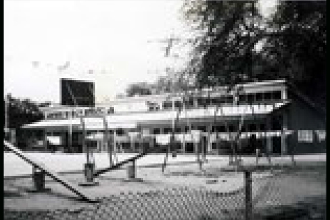 Playground at Upper Weld Road, built in the mid-1950s at Petain Road, c. 1966.
Courtesy of Urban Redevelopment Authority.
The provision of these play fields highlighted the nature of the arrangements made for this municipal town, which was meant to include family units. These quarters were not just large rooms that housed numerous coolies, but they also had quarters for married men with families. Clearly, this reflected how principles of modern town planning were applied here. Beyond concerns that open areas were necessary for clear air and healthy living, the planting of a domiciled community which included family units in the district provided a community catchment that could sustain the business and social-communal institutions rooted in Serangoon Road.
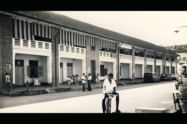
 This row of terrace houses at Upper Weld Road, built in the 1920s, was also called "Coolie Lines", c. 1966.
Courtesy of Urban Redevelopment Authority.
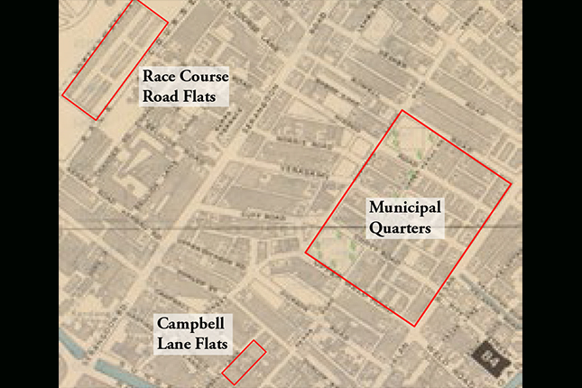
What is astonishing about this development is that the construction of Kampong Kapor estate was undertaken by the municipality even before the Singapore Improvement Trust (SIT), the colonial predecessor of the Housing & Development Board (HDB), had been empowered to erect pioneering townships. For this reason, the houses here were then called Municipal Quarters.
 These terrace houses were home to many Indian municipal workers, c. 1966.
Courtesy of Urban Redevelopment Authority.
Initially, municipal planners had only intended for these houses to accommodate government coolies and peons. However, by the time construction began, coolie lodgings were being developed into full-fledged housing estates.
After World War II (WWII), during the time of the British Military Administration, authorities established a temporary municipal market for this community at the site of the playground on Rowell Road. As one side of these grounds ran along the length of Hindoo Road, it was called the Hindoo Road Market. For a period of two years, it served the needs of the residents of this estate. It was closed in 1948.
In addition to Kampong Kapor, another cluster of government housing was built in 1927 on the grounds of Kandang Kerbau Hospital, on the side of Kampong Java Road. These houses were established for hospital staff, as well as government employees who were above the labouring class. These were known as Government Quarters.
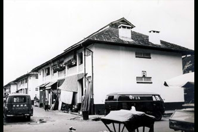
 Terrace houses at the junction of Veerasamy and Kampong Kapor Roads, built in the 1920s. The compound was enclosed with an external wall during the post-war years, creating a garden space for each unit, c. 1966.
Courtesy of Urban Redevelopment Authority.
Half a dozen blocks of flats were also erected at Race Course Road in 1940, at the junction of Rotan Lane. They consisted of 148 apartment units. This was the first SIT project in Serangoon Road. The Race Course Road flats were used to house artisans and other municipal staff, including hospital nurses. However, these flats did not survive the decade. By 1950, they were levelled and replaced by more than a dozen new SIT flats which stretched the entire length of the Farrer Park Field. This estate was named Princess Elizabeth Flats, and is not to be mistaken for the Princess Elizabeth Park Estate at Upper Bukit Timah Road.
Both Princess Elizabeth estates, however, shared similar beginnings. They were created with funds which were originally meant for celebrating the marriage of Princess Elizabeth. These funds were eventually donated to the municipality which then assigned them for public housing purposes. The flats at Race Course Road were occasionally inundated by flood waters during heavy downpours.
There was also a unique cluster of SIT flats, which sat at the junction of Campbell Lane (known today as Madras Road). Here, SIT managed to squeeze in several blocks of flats consisting of 24 houses. These were built in 1941, not as part of a housing estate, but to replace individual blocks of houses in the area that had become dilapidated and which required rebuilding. Today, only one block remains. It currently functions as the Madras Hotel.
Construction of SIT flats took a pause during WWII, but continued unabated soon after. The Princess Elizabeth Flats estate was extended to the other end of Farrer Park to form Farrer Park Estate. Around the same time, another SIT estate was also being built towards the Lavender Street side of Serangoon Road. These were the SIT flats of Petain Road which would later become known as Jalan Besar Estate. These flats have since given way to private developments.
Urban Development over the Years
What is interesting about the Little India public housing experience is that the district featured almost all the models of flats built during colonial times – from pre-SIT 1920s municipal quarters (terrace houses) at Hindoo Road to the subsequent generations of SIT flats that the government would go on to build. The first ones were no more than two levels high. Then, during the 1940s, SIT increased the height of these flats to three storeys, and by the 1950s, the flats built at Jalan Besar Estate, along Petain and Sturdee Roads, reached up to four storeys in height.
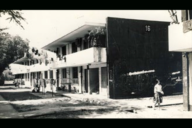
 Two-storey SIT block of flats built in the mid-1950s at Petain Road, c. 1966.
Courtesy of Urban Redevelopment Authority.
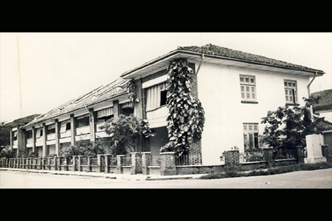
 A two-storey SIT flat at the junction of Petain and Sturdee Roads. This was one of the first SIT flats to be built in the area, c. 1966.
Courtesy of Urban Redevelopment Authority.
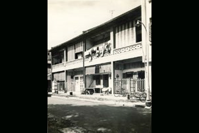
 A four-storey SIT flat at the junction of Petain and Sturdee Roads. These were the last SIT flats built along Serangoon Road, c. 1966.
Courtesy of Urban Redevelopment Authority.
The evolutionary progression of Little India’s urban development is worth noting. While terrace houses of the 1920s were built with internal staircases, the design of the 1940s SIT flats had evolved towards a more community-centric approach, featuring elements such as shared staircases. By the 1950s, the modern two and four-storey SIT flats at Jalan Besar Estate were being built with common corridors in the front, as well as staircases on both ends of the blocks.
At the junction of Petain and Marne Roads, there was a curious evolving design of a terrace-like housing block with a five-footway which went all around the ground level. This was a perfect example of the transition between the design of the old quarters and modern new flats. The five-footway, in this instance, was the first step towards the creation of common corridors in government housing. This preceded the coming evolutionary cycle of public flats in the 1960s and 70s, where the hanging of laundry poles moved from the front corridors towards the back of the flat.
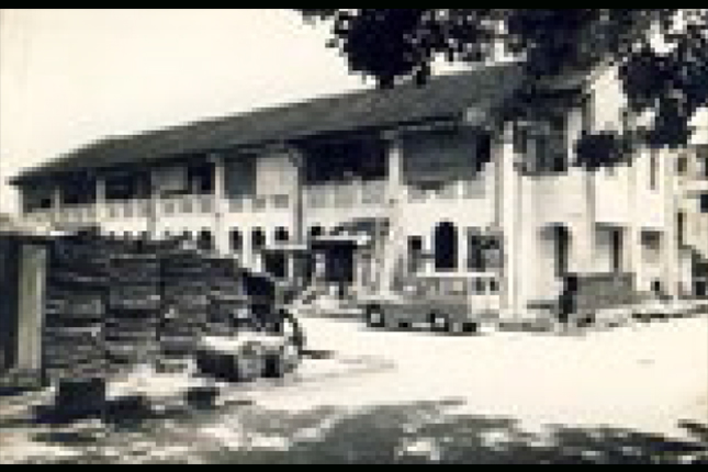 Two-storey SIT block of flats at the junction of Petain and Marne Roads, built in the early 1950s. These terrace houses featured a five-footway all around the ground level, c. 1966.
Courtesy of Urban Redevelopment Authority.
Communities and Enclaves
In an area covered by abattoirs, factories, shophouses and warehouses, the municipal and government quarters, as well as SIT flats, acted as crucial population centres which gave the Serangoon Road district the semblance of a kampong (Malay for "village") of multi-ethnic domiciled communities. This is the reason why such a great diversity of communal and religious institutions remains in the district till this day. Edifices sprouted all over Serangoon Road because the communities they served were also here.
Without these institutions and communities, this part of Serangoon Road would simply have evolved into an industrial and commercial district, and not the Little India that we know today. The flats in Serangoon Road helped to sustain the community, made up of businesses, schools, hospitals, religious institutions, as well as market and street stalls.
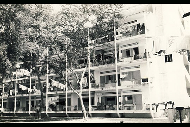
 Pre-war government flats at Serangoon Road.
Courtesy of National Archives of Singapore.
There’s much to be learnt from Serangoon Road’s forgotten urban heritage. In documenting the building of government quarters in the district across the years, one can truly appreciate the thinking and logic of Singapore's early planners and builders. Perhaps, the Serangoon Road urban experience serves as a microcosm of how public housing has evolved throughout Singapore’s historical districts. With this aspect of Singapore’s social-urban history being rediscovered, we can now add to our understanding of Little India and Singapore's urban heritage.
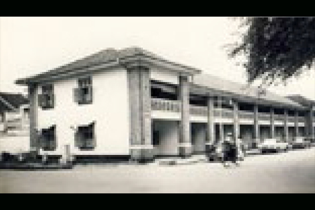
 Government housing along Serangoon Road in the 1950s.
Courtesy of National Library Board, Singapore.
Though much of this urban heritage may have vanished from Little India, memories of these spaces may still be recovered through archival research and new oral enquiries. There are also still a few remaining housing edifices at Hindoo Road and Madras Street, where you can appreciate how pockets of housing within Little India had once been the heartland for many of Singapore’s labouring pioneers.