Text and Images by Marcus Ng
Be Muse Volume 5 Issue 4 - Oct to Dec 2012
The journey to Semakau Landfill from the pier off Pasir Panjang takes about 40 minutes in a diesel launch with an oil-stained deck and (often) shirtless boatman. For most visitors, the trip begins long before daybreak, as the tide waits for no man and the tug of the moon is usually strongest hours before dawn. In the dark, the vessel swings past the refineries of Pulau Bukom as well as Pulau Jong, a tiny island named after a Chinese junk, before discharging its passengers at one end of a long wharf. At the other end of what was once an islet called Pulau Sakeng is a waste transfer station, a cavernous hall that emanates an air of industrial purpose as huge excavators unload ash from barges into off-road dump trucks.
Semakau Landfill is a place of contradictions, a land of stark yet striking contrasts. Dubbed a ‘Garbage of Eden’, a ‘Dump Wonderland’ and an ‘Island paradise built on a garbage dump’ by visiting journalists on a mission to discover Singapore’s unique solution for solid waste disposal, the island is a landfill that defies conventional expectations by doubling as a habitat for native biodiversity. Today in 2012, the landfill is a patchwork of cells spanning 350 hectares, designed to hold the city’s refuse until the year 2045 and hopefully beyond. But it is also home to shorebirds, sea stars, sea anemones and rare shellfish that thrive in mangroves, seagrass beds and a reef flat right next to a massive municipal facility. The air is fresh and the surrounding waters harbour dolphins, turtles and countless fish, for the cells contain mostly ash, the output of incineration plants that reduce the nation’s trash into inert fragments, and an impermeable membrane prevents the waste from contaminating the sea.
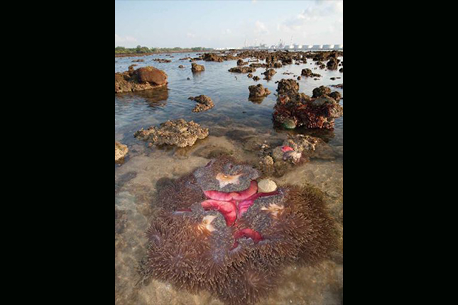
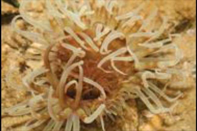
 Colonies of magnificent sea anemones (Heteractis magnifica) and colourful corals thrive on a reef flat just beyond the bund of Semakau Landfill.
When filled to the brim and covered by a layer of earth, each landfill cell transforms from a scene of desolation into a growing landscape of grasses, shrubs and trees where flocks of birds feed and roost. Birdwatchers make regular pilgrimages here to catch glimpses of endangered species such as the Malaysian plover and great-billed heron, while the wide open sky above the landfill draws budding astronomers who gather to observe distant stars and galaxies from atop a seven-kilometre perimeter rock bund. This embankment, which encircles the cells and links Pulau Sakeng with Pulau Semakau proper, unites the fate of two small islands with a recorded history nearly as long as that of modern Singapore.
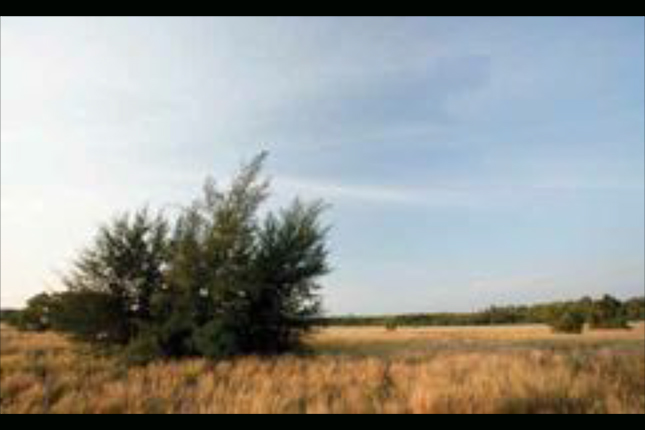 The landfill cells, when filled up and covered by a layer of earth, are soon overgrown by lalang and casuarina trees, becoming lush habitats for butterflies and birds.
BUILT FOR SUSTAINABILITY
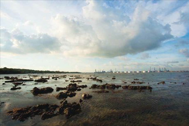
The bulk of visitors to Semakau Landfill have their sights set on the natural wonders of its western shoreline, where low spring tides unveil a mudflat teeming with fiddler crabs, sand stars and sea cucumbers.
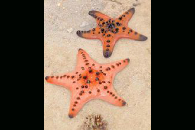 The stars of many a vist to Semakau Landfill are these colourful knobbly sea stars (Protoreaster nodosus), a locally endangered species that still survives in good numbers on the reef flats by the landfill.
Led by guides from companies such as the Lee Kong Chian Natural History Museum, every intertidal tour of Pulau Semakau is a walk on the wild side, a wade through waters full of sponges, corals and colourful marine creatures at home in this bustling corner of the Singapore Strait. Overhead, reef egrets, brahminy kites and sea eagles battle for hunting rights over tidal pools where shrimp and small fish are trapped.
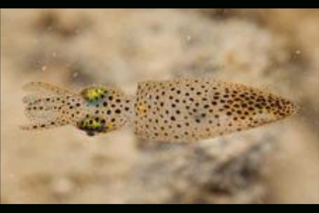 The pygmy squid (Idiosepius sp.), an inch-long hunter of small shrimp, is one of many curious marine invertebrates to live in the waters around Semakau Landfill.
Today, Pulau Semakau is best known as a haven for coastal wildlife and an outdoor classroom where students, families and nature lovers can see, touch and take back vivid memories of the flora and fauna that live alongside an active landfill. Staff from the National Environment Agency (NEA), which runs the facility, also implore visitors to reduce, re-use and recycle their waste as much as they can, so that the lifespan of the place can be extended for as long as possible. There is a ring of urgency to their pleas, for Semakau Landfill has served as Singapore’s only remaining solid waste disposal site since 1999, following the closure of the Lorong Halus dumping ground. Built at a cost of $610 million between 1995 and 1999, Semakau Landfill was a project of national exigency, as all existing dumping grounds were expected to be depleted by the turn of the 21st century and the mainland had run out of suitable sites for storing waste. Sheer necessity, rather than a fad for novelty, thus drove planners from the then Ministry of the Environment to look offshore and envision the possibility of reclaiming the shallow seabed between two islands south of Pasir Panjang to form a landfill that would last for decades to come.
The making of Semakau Landfill also marked a new chapter in the Singapore story, in the way economic growth and social needs were joined by environmental sustainability as a measure of success in the long run. Attaching the rock bund to Pulau Semakau entailed the inevitable loss of a chunk of the island’s original mangrove forests, while the building of the wharf and transfer station would result in considerable sedimentation. In response, two scientists, Professors Leo Tan and Lee Sing Kong, then respectively Director and Head of Biology at the National Institute of Education, drew up a plan to mitigate the environmental impact of the landfill on what was already recognised as a habitat of high biodiversity value. Their proposal, to create two new plots of mangroves to replace the 13.6 hectares lost to the construction, was accepted by the ministry, along with the recommendation of another marine biologist, Professor Chou Loke Ming from the National University of Singapore, to use floating silt screens to prevent sediment from choking nearby coral reefs. Today, thousands of healthy young trees grow near the base of the bund, providing habitats for crabs, mudskippers and otters, and serving as bio-indicators of marine pollution, while the waters around Pulau Semakau still support some of Singapore’s richest coral reefs, a slice of which can be viewed during public intertidal walks.
 Thousands of mangrove saplings were planted by Semakau Landfill to replace trees lost during its construction.
LIFE ON MANGROVE ISLAND
The making of Semakau Landfill was, however, a swan song to the communities who had lived and died on Pulau Sakeng and Pulau Semakau for over 150 years. Observant visitors to the latter’s western shoreline will note a sprinkling of eroded piles along parts of the beach as well as the foundations of long-vanished buildings amid the understorey of an overgrown forest. These are the few surviving traces of a village where as many as 1,600 people lived in dozens of timber houses lining the shore, set on tall beams to stay dry during the highest tides.
For reasons unknown, Pulau Semakau was marked as Pulau Barmalang in early maps, such as one drafted by Captain James Franklin of the East India Company in the early 1820s and currently on display in the Singapore History Gallery at the National Museum of Singapore. The island could have been occupied or at least visited much earlier, as archaeologists found 18th century Qing porcelain pieces and older fragments while exploring the place in 1991. By 1844, however, the island was already referred to as Pulo Simakow or Mangrove Island, as documented by a Singapore Free Press report on a pirate attack that resulted in the death of an unfortunate villager. The islanders then, about a dozen strong, consisted of Chinese smallholders who cultivated vegetables and raised poultry. They also burned charcoal, probably made from the wood of bakau or Rhizophora mangrove trees that grow abundantly around the island, and which were probably the source of the name ‘Semakau’. The original island was flame-shaped, just over a kilometre wide and spanned 2.1 kilometres from its northern tip, known as Tanjong Romos, to its southernmost point, Tanjong Penyelai. To the east was a dense mangrove swamp, while a sandy beach and mudflat faced the western front. In between was scrubland which islanders cleared to plant coconuts, fruit trees and vegetables.
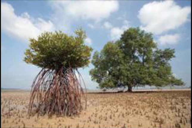 Prominent stilt roots or pencil roots allow mangrove trees to breathe and survive on the mudflat of Pulau Semakau.
More settlers, principally Chinese of Teochew origin, arrived in the early 20th century. By 1955, Pulau Semakau was home to about 780 villagers, both Chinese and Malay, who farmed the land and raised goats and poultry. Those who fished used small manoeuvrable craft called kolek as well as traditional fish traps and nets to harvest valuable species such as bream, mullets, groupers, snappers, stingrays and scads. Some of the catch was consumed by the fishermen’s families, but the bulk was sold to middlemen from mainland markets.
Singapore’s attainment of self-rule in 1959 and full independence in 1965 was a mixed blessing for the community, for the threat of foreign pirates, and later, the turbulent years of Konfrontasi with Indonesia between 1963 and 1966, prevented them from venturing into good fishing grounds. As a result, some islanders sought new livelihoods in Pulau Bukom, Jurong and Kallang or moved to the mainland. But in the late 1960s, Pulau Semakau received a population boost when villagers from Pulau Bukom were resettled to make way for new petrochemical facilities.
The residents of Kampong Tengah, as the village on Pulau Semakau was called, lived in about 160 houses. Life in Kampong Tengah, though adequate for its time, was primitive by today’s standards. Village wells were unreliable, and fresh water had to be ferried over from Pulau Bukom. Electricity was available only in the evenings when a generator was switched on. As there were no sewers, the villagers used communal latrines positioned over the water so that the sea would wash away their waste. Healthcare was a weekly affair provided by a nurse in a boat from Pulau Brani known as the Floating Dispensary.
Serving the village was a mosque, a community centre, a football field, a police post as well as Muslim and Chinese burial grounds. A primary school opened in 1951 with seven teachers, one of whom was former Senior Minister of State for the Environment, Mr Sidek Saniff. Basic education notwithstanding, the children went about barefooted, seldom bathed or brushed their teeth, and boasted dirty fingernails.
The history of Kampong Tengah drew to a close in 1977, when the villagers were relocated to the mainland, leaving Pulau Semakau to the whims of nature for some 20 years.
LORE AND LEGEND ON PULAU SAKENG
Similar scenes of kampung life existed on Pulau Sakeng, an islet barely half-a-kilometre long located about 1.6 kilometres east of Pulau Semakau. Though marginally shorter than its neighbour’s, the history of this tiny rock is somewhat more intriguing. The earliest record of the place came from a surgeon, Dr Robert Little (whose younger brother founded John Little & Co.), who surveyed the southern islands in 1848 and found on Pulo Siking [sic] about 30 inhabitants occupying seven well-built houses on the slope of a hill.
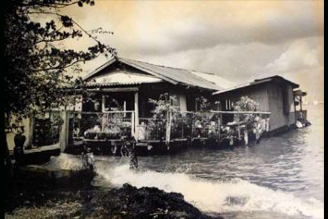 Sitting on stilts just out of reach of the highest tides, this house at Pulau Sakeng once doubled as a provision store and dwelling for two brothers, Mr Teo Yen Eng (b. 1924) and Mr Teo Yan Teck (b. 1932), who now reside on the mainland. Photo courtesy of Mr Teo Yen Eng.
Dr Little also noted a narrow belt of mangroves around the island as well as the presence of coconuts and fruit trees. This observation was echoed by the memories of Haji Ghani bin Dualip, a former assistant headman who recalled that the island was once known as Pulau Kelapa or ‘Coconut Island’. The villagers, thought to have originated from Riau or descended from the Orang Selat (People of the Straits) who once dwelt by Singapore’s shores, claimed links with the Johor-Riau sultanate, which once ruled much of the archipelago; older residents would cite a curse that befell the island after the 1699 assassination of Sultan Mahmud II, which barred the islanders from setting foot in Johor for seven generations.
According to local lore, a lady of Riau blood named Keng arrived at the island more than 200 years ago. A woman of doughty temperament, Keng became chieftain after healing the sick and saving the villagers from pirates. The island later bore her name and until it was reclaimed for the landfill, a shrine or keramat on the hilltop of Pulau Sakeng was said to have been her tomb. Like the surviving keramat on Kusu Island, Keng’s shrine was reputed to be a source of blessings for pilgrims who paid their respect at the site. Other sources claimed that Keng and her descendants were in fact pirates, which was plausible as the islanders enjoyed a reputation for maritime robbery even in the late 1800s, when men from Pulau Sakeng would raid passing vessels laden with prized goods such as cigarettes.
Only a few families lived on Pulau Sakeng before the Second World War. The population grew during the war as some people left the mainland to stay with their relatives on the island. In the 1950s and 1960s, villagers from Pulau Sebarok and Pulau Bukom also arrived after their islands were developed. By the early 1980s, Pulau Sakeng had a population of about 520, some of whom worked on the mainland or at Pulau Bukom. Others gathered seashells, fished or raised chicken and geese. A mosque, primary school, religious school, clinic, sundry shop and police post served the close-knit community, who lived in about 80 houses on stilts by the water’s edge. Until the 1970s, one annual highlight for the islanders was a National Day regatta, during which villagers would compete with their peers from Pulau Semakau, Pulau Sudong and Pulau Seraya in boat races and swimming contests.
On weekends, mainlanders would visit the island to sightsee and photograph the last traditional village in the southern islands of Singapore. But few spent as much time there as Normala Manap, a researcher who visited Pulau Sakeng in the early 1980s to document its ethnography. Asked what she remembers most fondly about the island, she had this to say:
“Everything! To name a few, I miss the connectedness on the island, both of the region and in the island. The people had relatives from the Riau islands who came to visit the island by boat. Everyone on the island knew one another. There was great unity in the community and decisions were made together. When there was a celebration, all were invited. Their emphasis was on what's important in life: communication and building relationships, namely the ties that bind. This is also represented in the way their houses were designed – the verandahs always looked towards the village square or thoroughfare; this is intended so one can always greet passers-by.
They also had a very different worldview in relation to nature. They believed that all things in nature have spirits. The trees, water and even rocks have spirits and as a result they treat nature with great reverence. Their knowledge of their environment, the tides, the plants, was intimate; they could tell the weather from the ripples in the sea and the changing hues of the skies. They even named themselves after trees, flowers and sea creatures. Some of their names were also references to their everyday preoccupations – 'Jala' is a common name, which is also the word for 'net', while the name 'Malam' refers to 'night' in Malay. It’s a pity that people of this generation no longer get to experience these cultures and ways of life that are integral parts of our history and who we are today.”
Manap also noted the presence of a white kaolin outcrop as well as a line of reddish coral-stone blocks – unusual structures that hinted at long-forgotten human activity and whose origin was unknown to the final generation of islanders. These and other past mysteries, however, no longer trouble the present, for no traces of the original island survive and the former villagers are now scattered across the mainland, far in mind and essence from their childhood home.
HABITATS IN HARMONY
The story of Pulau Sakeng came to an end in 1994 when the remaining 130 or so residents bid farewell to their ancestral isle before contractors and cranes arrived to turn the place into a miracle of modern engineering and a model for urban environmental sustainability. Semakau Landfill began operations on 1 April 1999. Six years later, following a visit by then Minister for the Environment and Water Resources Dr Yaacob Ibrahim, the landfill assumed a second life as a public showcase for Singapore’s ability to marry development with the preservation of natural habitats.
Since then, more than 60,000 people from Singapore and abroad have set foot on a facility where one can find respite from the noise of the city and revel in a vision of how much of Singapore’s coastline was like before it was reclaimed for docks, shipyards and artificial waterfronts. Here, on the reef flat of Pulau Semakau, man has left little evidence of his presence, save the footprints of fellow tidechasers and the glittering towers of Pulau Bukom on the northern horizon.
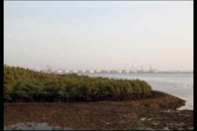
 The sea returns to cover the reef flats after a few hours of low tide that allow visitors to explore these intetidal habitats. Semakau Landfill's mangroves and the refineries of Pulau Bukom can be seen in the background.
Nature guides in khaki and rubber booties shepherd their charges down a well-trodden path through the seagrass and but soon struggle to maintain the cohesion of the groups as the eyes of each and every visitor are drawn to myriad creatures creeping, sliding, climbing and swimming in shallow pools and on rocky outcrops. Seahorses, giant clams, hairy crabs, sea slugs, octopuses, flatworms and anemonefish take turns to hog the limelight but there is never enough time to learn all their secrets, for the tide soon returns to swamp the reef, forcing everyone to turn back and head for the bund.
 Living in a tube embedded in the sand, a peacock anemone extends its tentacles to feed when the tide rises to cover the reef flat.
Semakau Landfill, as every visitor learns, is a place of contradictions. It is a landfill that is clean and green, maintained with care and devotion to ensure the integrity of the cells as well as the health of its ecosystems. It is a refuge for many rare and endangered species that thrive in the shadow of a colossal seawall. Above all, it is a glimpse into a future in which habitats can exist in harmony with the needs of humanity, as well as a unique chance to witness Singapore’s oft-overlooked biological wealth and learn how a country can grow without losing sight of its natural history.
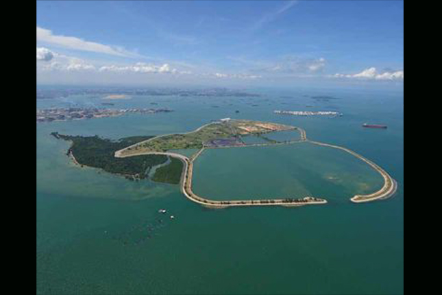 An aerial view of Semakau Landfill, showing the heavily wooded Pulau Semakau on the left and the perimeter bund on the right. Photo courtesy of the National Environment Agency.
Marcus Ng is the author of Habitats in Harmony: The Story of Semakau Landfill, a book chronicling the history, development and biodiversity of Semakau Landfill, published by the National Environment Agency (1st edition, 2009, 2nd, revised edition, 2012)