TL;DR
Graves are a rich source of heritage information. Not only do they tell us stories through their inscriptions and features, but also in how they are laid out over time. The Bukit Brown Documentation Project (2011-2014) collected the Global Positioning System (GPS) coordinates of close to 4,000 graves. Coupled with the dates recorded on most of the graves, the research team was able to conduct spatial-temporal analyses for the the Bukit Brown Cemetery, Singapore’s first Chinese municipal cemetery, and the adjacent Seh Ong Cemetery, a Chinese clan association cemetery for the Ong clan originating from Fujian Province in China.
The Evolution of Cemetery Research and the Impact of Digital Technology
Cemetery research in Singapore has undergone three phases. The first phase saw “scattered efforts” at documentation by forerunners like H.A. Stallwood, Alan Harfield and David Chng over much of the 20th century (Hui 2020: 30). This phase reflected the conventional approach of recording inscriptions and researching biographies of the interred. In the second phase in the early 2000s, a “fraternal glow” emerged among enthusiasts, activists and researchers that saw cemeteries not just as subjects for historical studies, but as heritage sites (Hui 2020: 31). This expanded the lens of study beyond history to incorporate culture and nature, among others (Tan 2011). In the third and most recent phase, civic and multidisciplinary engagement has resulted in more holistic documentation work for the Kwong Hou Sua Teochew Cemetery in 2008-09 and the Bukit Brown and Seh Ong cemeteries in 2011-14 (Hui 2020: 31-33).
Digital technology has greatly expanded the scope of what can be documented. The ThakBong project in Taiwan demonstrated how digital photography could capture not just inscriptions but also features of graves, through geo-tagged pictures (Streiter, Goudin and Huang 2010). Indeed, digital technology coupled with Geographic Information System (GIS) applications have led to a proliferation of GIS-related mapping and analysis of cemetery data in recent years (Brewer 2016; Altaweel 2018).
One prime example of using GIS to analyze a cemetery as cultural landscape is Pritsolas and Acheson (2017). Through the analyses of gravestone morphology, temporal evolution and spatial movement, the study was able to derive socio-economic and cultural patterns in the cemetery landscape. Similarly, Streb, Kolnberger and Kmec (2019) demonstrated how GIS could reveal regions of similar materials, shapes, and decors in a cemetery, which reflected not only the socio-economic status or cultural backgrounds of the deceased, but also implicit emulation from the neighboring environment. Furthermore, Filzwieser and Eichert (2020) suggested a historical GIS approach that leverages historical spatial data such as maps, aerial photographs, and cemetery records, so as to provide better understanding of the historical landscape, and thus the sense of place. These studies proposed ways in which different layers of data could be juxtaposed and analyzed for a more comprehensive understanding of cemeteries as cultural and historical landscapes, which we have applied to the Bukit Brown and Seh Ong cemeteries.
Background to the Bukit Brown and Seh Ong Cemeteries
The Seh Ong Cemetery was established by the prominent Ong clansmen Ong Kew Ho, Ong Ewe Hai and Ong Chong Chew when, in 1872, they bought 211 acres of land from Lim Chor Ghee and Mootapa Chitty for $1,500. The land was to be used for the residential, agricultural and burial purposes of their Ong clansmen from Fujian.
The origins of Bukit Brown Cemetery can be traced back to 1906, when Dr Lim Boon Keng first mooted the idea of a Chinese municipal cemetery to the Municipal Council. At that time, Chinese in Singapore were buried in private family plots or clan association burial grounds, which were becoming overcrowded. Although the Municipal Council passed the motion unanimously, the process of finding land for the new cemetery was long drawn out, and it was only in 1918 that the municipal government began to look for suitable burial grounds in the Bukit Brown area. In Nov and Dec 1919, the municipal government acquired four lots of land for this purpose – Lots 33, 3801, 3805 and 99303 – the last of which (98 acres) belonged to the Ong clansmen and served as part of the Seh Ong Cemetery. This is why both cemeteries are adjacent to each other.
Subsequently, Bukit Brown Cemetery was opened in 1922. Although the initial response was lukewarm – only 93 burials took place in its first year of operation – the cemetery became increasingly popular and was fully populated by 1944 during the Japanese Occupation. Thereafter, only those with reserved plots could be buried in Bukit Brown Cemetery, which was finally officially closed to burials in 1973 (Hui 2019: 170-171).
Different Organization and Burial Patterns of the Cemeteries
Seh Ong Cemetery was divided into five sections or hills. Based on our spatial-temporal data of the graves in Hill 1 and Hill 3, they were sporadically populated over time, with no uniformity to the size or facing direction of graves. This accords with patterns usually found in conventional clan association cemeteries, where larger, choice plots on higher elevations were acquired or reserved by the rich Chinese elite. Moreover, the facing direction of graves was determined by fengshui (geomancy) considerations, with implications for the fortunes of descendants, and so differed from grave to grave.
In contrast, the grave plots and facing direction of graves in Bukit Brown Cemetery were standardized, as required by the municipal government. Moreover, the five Blocks of the cemetery, drawn out after the land was acquired and before the cemetery was opened, were populated sequentially from Blocks 1 to 5. Based on data gleaned from the Bukit Brown Burial Register, the first burials in the respective blocks are as follows:
Block 1 - Apr 1922
Block 2 - Jan 1924
Block 3 - Sep 1928
Block 4 - Oct 1934 (Pauper); Nov 1935 (General)
Block 5 - Apr 1940
These differing organization and burial patterns in the two adjacent cemeteries are apparent when we map out the graves and their facing directions (Figure 1). Graves in the Seh Ong Cemetery are concentrated on lower elevations near the road while those on higher elevations are sparser. There is also no standard facing direction for the graves. In Bukit Brown Cemetery, graves are neatly spaced out following a grid-like format, and the facing direction is standardized for each block and division.
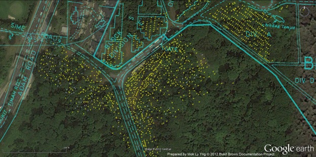 Figure 1: Comparison of the layout of graves in Bukit Brown and Seh Ong cemeteries
Distribution of Graves Affected by Road Works
The announcement of plans to construct an eight-lane carriageway cutting through both cemeteries in 2011 would necessitate the exhumation of about 3,700 graves, in Blocks 1 to 5 of Bukit Brown Cemetery and mainly Hills 1 and 3 of Seh Ong Cemetery (see Figure 2 below). The documentation of these graves in the aforementioned Bukit Brown Documentation Project meant that data is available from all blocks of Bukit Brown Cemetery. Although not a statistically representative sample, it does mean that we have data from all periods of the cemetery’s occupation history for spatial-temporal analysis.
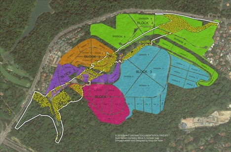
Figure 2: Distribution of affected graves across Bukit Brown and Seh Ong cemeteries
Distribution of the Earliest Qing Dynasty Graves
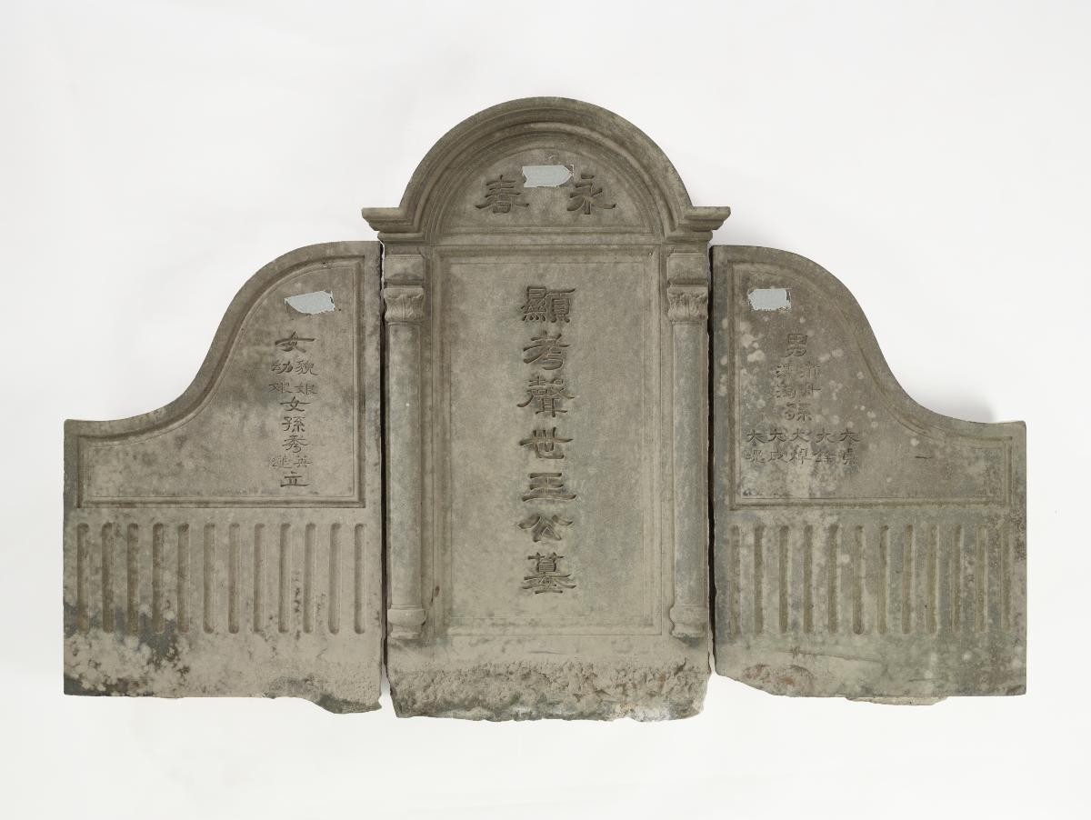
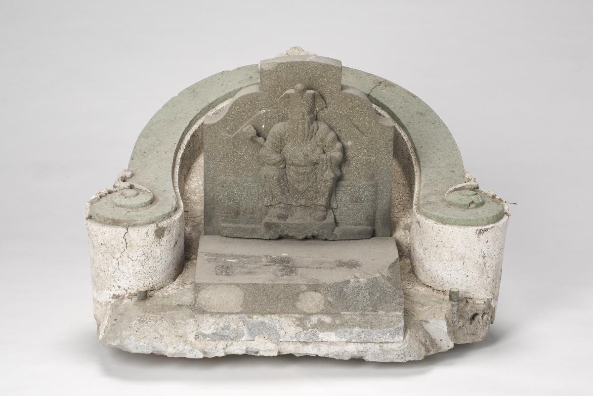
Visitors to Bukit Brown and Seh Ong cemeteries would have noticed the presence of headstones dating back to the Qing dynasty. These may be recognized by the words huang qing (皇清, a reference to the Qing Dynasty) inscribed on the headstones, as well as dates that reference the reigns of the different Qing dynasty emperors. Since Bukit Brown Cemetery was opened in 1922, after the end of the Qing dynasty following the Xinhai Revolution of 1911, we may assume that these graves found in Bukit Brown Cemetery were relocated from other cemeteries. Conversely for Seh Ong Cemetery, since the land was acquired in 1872, it is highly likely that graves dating back to the reigns of Guangxu Emperor (1875-1908) and Xuantong Emperor (1908-1911) represent original burials in the cemetery.
Table 1 below summarizes the distribution of 282 Qing dynasty graves that we have records of. The majority (176 graves) are found in Hills 1 and 3 of Seh Ong Cemetery, while 106 graves are found in Blocks 2-5 of Bukit Brown Cemetery. Of these, an overwhelming majority of the graves date back to the reign of the Guangxu Emperor (195 graves).
|
Emperor |
No of graves |
Block 2 |
Block 3 |
Block 4 |
Block 5 |
Seh Ong Cemetery Hill 1 |
Seh Ong Cemetery Hill 3 |
|
Daoguang Emperor (1820 - 1850) |
17 |
11 |
6 |
|
|
|
|
|
Xianfeng Emperor (1850 - 1861) |
18 |
7 |
6 |
3 |
|
1 |
1 |
|
Tongzhi Emperor (1861 - 1875) |
35 |
16 |
16 |
1 |
1 |
|
1 |
|
Guangxu Emperor (1875 - 1908) |
195 |
9 |
16 |
10 |
2 |
22 |
136 |
|
Xuantong Emperor (1908 - 1911) |
17 |
1 |
|
1 |
|
5 |
10 |
|
Total |
282 |
44 |
44 |
15 |
3 |
28 |
148 |
Table 1: Distribution of Qing dynasty graves by time period and location
Figure 3 below shows the distribution of Qing dynasty graves in the two cemeteries. It can be seen that Qing dynasty graves in Seh Ong Cemetery are mainly Guangxu era graves clustered on the lower elevations of Hill 3 near the road. For Bukit Brown Cemetery, we observe major clusters of graves in Blocks 2 and 3, and it is likely that they were relocated collectively from the same cemeteries. Other Qing dynasty graves distributed sporadically across Blocks 2-5 are more likely to have been relocated individually from private cemeteries.
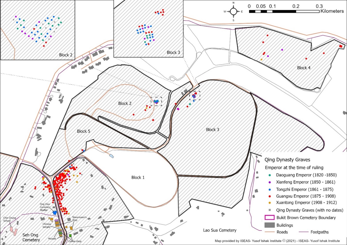
Figure 3: Distribution of Qing dynasty graves across Bukit Brown and Seh Ong cemeteries
Populating Bukit Brown Cemetery
Table 2 shows how the different Blocks of Bukit Brown Cemetery were occupied over five-year periods since its opening in 1922. As we only have data of graves in the affected area, the sample is not statistically representative, and very likely under-represents graves from the 1932-1936 period.
Nevertheless, the historical sequential pattern through which the cemetery was occupied, as shown by the data, accords with what is found in the burial register. Burials peaked during the Japanese Occupation (matching the 1942-1946 period in Table 2 below). Thereafter, burials took a significant dip as only those with reserved plots could be buried in the cemetery.
|
Time period |
No. of Graves |
Block 1 (1922 Apr –) |
Block 2 (1924 Jan –) |
Block 3 (1928 Sep –) |
Block 4 (1934/35 –) |
Block 5 (1940 Apr –) |
|
1922 to 1926 |
155 |
139 |
16 |
0 |
0 |
0 |
|
1927 to 1931 |
328 |
1 |
191 |
134 |
0 |
0 |
|
1932 to 1936 |
22 |
2 |
10 |
6 |
4 |
0 |
|
1937 to 1941 |
816 |
23 |
17 |
40 |
595 |
143 |
|
1942 to 1946 |
1354 |
47 |
182 |
101 |
789 |
235 |
|
1947 to 1951 |
23 |
2 |
6 |
2 |
3 |
10 |
|
1952 to 1956 |
16 |
3 |
2 |
0 |
3 |
8 |
|
1957 to 1961 |
11 |
1 |
1 |
0 |
3 |
6 |
|
1962 to 1966 |
18 |
4 |
3 |
2 |
3 |
6 |
|
1967 to 1971 |
12 |
3 |
4 |
0 |
2 |
3 |
|
1972 to 1976 |
3 |
1 |
0 |
0 |
0 |
2 |
Table 2: Distribution of graves in Bukit Brown Cemetery by time period and location
When we look at Figure 4, which shows the occupation of the different blocks of the cemetery over different time periods, the spatial pattern of burials during the Japanese Occupation (largely marked by the blue dots representing the 1942-1946 period) is revealing. In all the blocks, we find rows of blue dots running through neatly arranged graves of earlier time periods. This is likely the result of graves occupying what would have been pathways in the different blocks due to the lack of burial space in the cemetery. The same reason could account for the congested pattern of burial on the fringes of Blocks 2, 3 and 5 during the same time period. Thus, through a GIS mapping of the graves over time, we begin to see how the surge of burials during the Japanese Occupation disrupted the spatial organization of the cemetery, which in turn is symptomatic of the exceptional times.
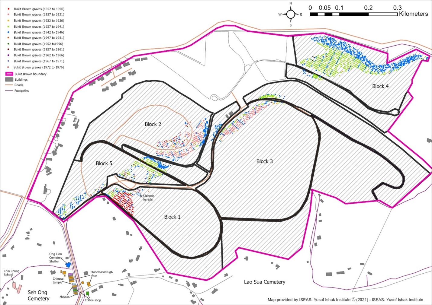
Figure 4: Occupation of Bukit Brown Cemetery over different time periods
Next Steps for Cemetery Studies
This article is based on preliminary findings of a project that seeks to analyze a rich set of data from the Bukit Brown and Seh Ong cemeteries through a GIS framework. With the collection of GPS coordinates, GIS enables micro-geographic analysis that unveils unique and non-random spatial patterns otherwise invisible to conventional analysis. By matching spatial patterns that we observe with the dates of the graves and cultural history of the cemeteries, we begin to unearth patterns that might have been buried with the passage of time. Future work will bring the material culture and features of the graves into the analysis, further enriching cemetery studies.
This project was supported by the National Heritage Board's Heritage Research Grant.
Notes
- Altaweel, Mark. 2018. “Using GIS to analyze the geography of cemeteries”. GIS Lounge, https://www.gislounge.com/using-gis-analyze-geography-cemeteries/ (accessed 25 January 2023)
- Brewer, Ross. 2016. “ArcGIS keeps past alive in municipal cemetery”. ARCNEWS https://www.esri.com/about/newsroom/arcnews/arcgis-keeps-past-alive-in-municipal-cemetery/ (accessed 25 January 2023)
- Filzwieser, Roland and Eichert, Stefan. 2020. “Towards an online database for archaeological landscapes. Using the web based, open source software OpenAtlas for the acquisition, analysis and dissemination of archaeological and historical data on a landscape basis”. Heritage, 3 no 4: 1385-1401.
- Hui, Yew Foong. 2019. “Bukit Brown chronicles: A brief cultural history of the Chinese in Singapore through the lens of a cemetery”. In A general history of the Chinese in Singapore, edited by Chong, Guan Kwa and Bak, Lim Kua, pp. 169-181. World Scientific.
- Hui, Yew Foong. 2020. “An essay on the development of cemetery research and documentation in Singapore”. In Heritage in Singapore: Saving history to build a nation, edited by Lim, Chen Sian and Chew, Rachel, pp. 29-33. ICOMOS Singapore.
- Pritsolas, Joshua and Acheson, Gillian. 2017. “The evolution of a small midwestern cemetery: Using GIS to explore cultural landscape”. Material Culture, 49 no 1: 49-77.
- Streb, Christopher K., Kolnberger, Thomas, and Kmec, Sonja. 2019. “The material culture of burial and its microgeography: A Luxembourg cemetery as a methodological example of an object-centred approach to quantitative material culture studies”. Material Culture, 24 no 3: 334-359.
- Streiter, Oliver, Goudin, Yoann, and Huang, Chun Jimmy. 2010. “ThakBong, digitalizing Taiwan's tombstones for teaching, research and documentation”. TELDAP International Conference: 1-13.