TL;DR
Benchmarks are all around us, though they are barely noticeable. Recently, one dating to the 1930s was discovered at the National Museum of Singapore building. The relic measures a mere two centimetres, but belying its size is an important function.

MUSE SG Volume 15 Issue 02 - July 2022
Text by Mok Ly Yng, Map Research Consultant; Rashid Md Noor, Assistant
Manager, Survey Services, Singapore Land Authority; Sharon Lim, Senior
Manager, Heritage Research & Assessment, National Heritage Board
Read the full
MUSE SG Vol. 15 Issue 2
Image above: A bolt-style benchmark from the 1930s. The bolt head measuring two centimeteres in diameter is screwed into the middle of the square plate.
“The city… does not tell its past, but contains it like the lines of a hand, written in the corners of the streets, the gratings of the windows, the banisters of the steps, the antennae of the lightning rods, the poles of the flags, every segment marked in turn with scratches, indentations, scrolls.”
– Italo Calvino1
The serendipitous discovery of two 19th-century granite boundary markers in October 2021 in Dover Forest stirred public interest in land histories and survey-related matters. Carefully extracted and accessioned into the National Collection to be preserved for posterity (see page 20 on the conservation process of the boundary markers), these two blocks of granite not only reveal the extent of landownership by two prominent merchants in colonial Singapore, but also historical methods of land survey.
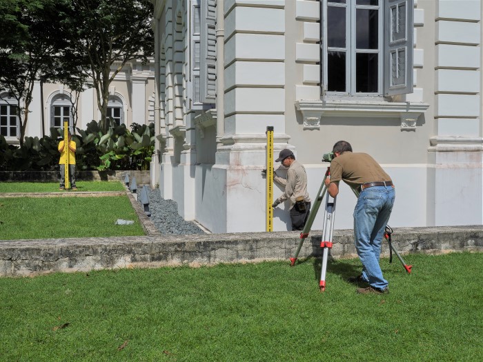
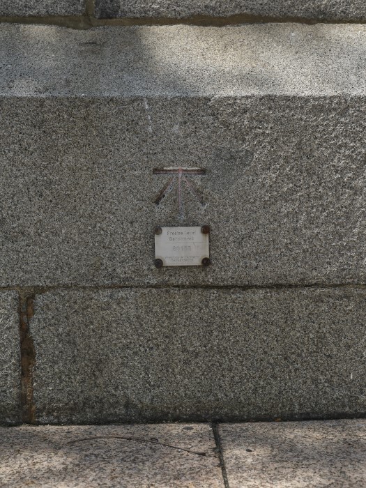
 A benchmark from the 1930s is located at the southeastern corner (circled) of the National Museum of Singapore main building.
After the two boundary markers were found, the National Heritage Board’s (NHB) Heritage Research and Assessment Division embarked on a collaboration with the Singapore Land Authority’s (SLA) Survey and Geomatics Division to document other historical survey markers. In March 2022, SLA’s land surveyors, also known as geomatics engineers, brought a team from NHB to a familiar place—the National Museum of Singapore—to show them a survey marker that had been recently discovered.
 A benchmark in the bolt form, which is drilled into a vertical surface. The flat surface on the bolt head is where a leveller would be placed to determine the elevation of a nearby location. Image courtesy of Singapore Land Authority.
Led to the southeastern corner of the front of the main museum building, the NHB team, expecting to see a marker like a hefty granite boundary marker, stood perplexed as the land surveyors pointed downwards to a portion of the wall where a layer of the painted concrete had been hacked. Framed by the rest of the intact wall and pebbles on the ground was a thoroughly unremarkable, very modestly sized squarish brownish patch sitting perpendicular to the ground. The NHB staff bent down to take a closer look: a square plate reddish-brown with rust was embedded into the wall, and screwed into the centre of the plate was a round bolt measuring a mere two centimetres in diameter. This bolt, the SLA team shared matter-of-factly, is a benchmark from the 1930s.
What is a Benchmark?
The highest point in Singapore is the summit of Bukit Timah. Arriving at the summit of the hill, one is greeted with a boulder bearing an inscription that states a height of 163.63 metres—but what exactly does this mean and how was this measurement derived?
There are several ways to measure land elevation. The most accurate method is levelling whereby the elevation, or height, of a terrain is determined or verified in relation to a datum, which is usually the mean sea level.2 The elevation value that is obtained through this method would then be recorded in a survey marker—a benchmark.
 A levelling staff (centre) is placed on top of the benchmark, and the
total elevation value is taken (right). To find out the elevation, or
height, of another location (left), the elevation value of the benchmark
is used as a point of reference.
A levelling staff (centre) is placed on top of the benchmark, and the
total elevation value is taken (right). To find out the elevation, or
height, of another location (left), the elevation value of the benchmark
is used as a point of reference.
Benchmarks come in a variety of designs and forms according to the period during which they were installed, but all of them perform the same function: each one serves as a stable reference point for determining the elevation of a nearby location. The earliest benchmarks were simply chiselled into vertical surfaces using the symbol of a broad arrow below a horizontal line. The middle of the horizontal line represents the height at that spot with reference to a particular datum. An angle-iron could be placed in the depression of the horizontal line to form a level surface—known as a ‘bench’—on which a levelling staff could be positioned accurately.
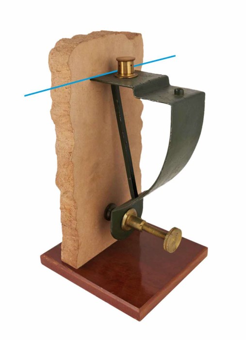 An angle-iron dating to 1914. A levelling staff would be placed at the
‘bench’ as indicated by the blue line. Image courtesy of
Science Museum Group
An angle-iron dating to 1914. A levelling staff would be placed at the
‘bench’ as indicated by the blue line. Image courtesy of
Science Museum Group
The benchmark at the National Museum takes the form of a single, round bolt, without any inscription, screwed into a square plate. Both the benchmark and the plate are probably made of cast-iron. The relic was discovered through SLA’s archival records of historical elevation values that were at times accompanied by location sketches.
With a known elevation value, this benchmark can still be used to determine the elevation of a nearby terrain. To do this, a land surveyor would place a levelling staff at the top of the bolt and thus determine the elevation value of another location using the museum’s benchmark as a point of reference.
One of the oldest existing benchmarks, likely etched in 1882, is found at the northern abutment of Cavenagh Bridge, which was built in 1869. Incidentally, this bridge is the oldest one across the Singapore River and was gazetted as a national monument in 2019. Despite its age, the Cavenagh Bridge benchmark is still in use today.
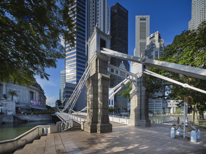
 The oldest existing benchmark, dating to around 1882, at the northern
abutment of Cavenagh Bridge. The benchmark is depicted by the traditional
chiselled broad arrow with a horizontal line above. The middle of the
horizontal line represents the height at that spot with reference to a
particular datum.
The oldest existing benchmark, dating to around 1882, at the northern
abutment of Cavenagh Bridge. The benchmark is depicted by the traditional
chiselled broad arrow with a horizontal line above. The middle of the
horizontal line represents the height at that spot with reference to a
particular datum.
Benchmarks are also shown on some maps, depicted using the arrow symbol or labelled ‘B.M.’, as well as in various British Admiralty charts of Singapore. The Cavenagh Bridge benchmark, for instance, is seen in an 18813 map and an 1893 map of Singapore.
History of Benchmarks and the Levelling System in Singapore
Singapore inherited the system of levelling and benchmark design from the British, who conducted their first precise levelling in the UK between 1840–60 in England and Wales using the mean sea level as the datum. Specifically, the mean sea level was obtained via tidal observations carried out at the Victoria Dock in Liverpool in 1844. The term ‘benchmark’ thus began to be used in the context of levelling.
In Singapore, the former Survey Department adopted the same survey technique, with the earliest tidal observations for land surveying purposes conducted by the then Public Works Department in 1882–83. This set of readings was taken at the Singapore River near the northern abutment of Cavenagh Bridge where the aforementioned benchmark is located.
The Survey Department was at the time just a stone’s throw away, housed in the municipal building known later as Empress Place Building and now home to the Asian Civilisations Museum.
In 1937, however, the Survey Department adopted a datum based on tidal readings taken at Victoria Dock, which was located at what is known today as Keppel Habour in Tanjong Pagar. Originally known as the Survey Department Datum, it was renamed as the Singapore Height Datum in 2015—the official standard that is presently used by SLA.
 In 1937, the former Survey Department adopted a datum for benchmarks based
on tidal readings taken at Victoria Dock (pictured here in the 1890s) in
Tanjong Pagar. The dock was demolished in 1982. Image courtesy of
Children’s Museum Singapore
In 1937, the former Survey Department adopted a datum for benchmarks based
on tidal readings taken at Victoria Dock (pictured here in the 1890s) in
Tanjong Pagar. The dock was demolished in 1982. Image courtesy of
Children’s Museum Singapore
To avoid confusion stemming from benchmarks based on different datums, which would result in inaccurate measurements, in 1958 the chief surveyor of Singapore established a precise levelling network covering the whole of Singapore based on the Survey Department Datum. This network comprised 68 ‘precise level benchmarks’ placed in the form of a closed loop around the main island. Subsequently, five more island-wide levelling exercises were conducted to densify and upgrade this infrastructure in 1977, 1983, 1987, 1994 and 2009. These benchmarks were all based on the Survey Department Datum.
Presently, there are approximately 450 precise level benchmarks maintained by SLA. They are installed along major roads across Singapore, each spaced about one kilometre apart. These modern benchmarks are simply a bolt set in concrete or stone, not unlike the benchmark at the National Museum dating to the 1930s, albeit with more identification information surrounding the modest bolt.
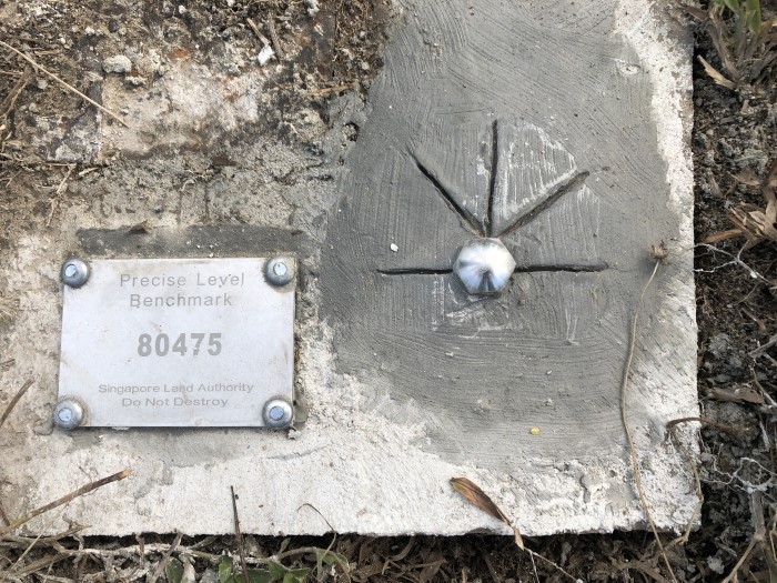 A modern precise level benchmark located at Tuas South Drive, 2019. The
benchmark comprises a bolt set in concrete, with a plate detailing its
unique identification number. Image courtesy of Singapore Land Authority
A modern precise level benchmark located at Tuas South Drive, 2019. The
benchmark comprises a bolt set in concrete, with a plate detailing its
unique identification number. Image courtesy of Singapore Land Authority
Historical Relics
In spite of Singapore’s profound transformation since independence, a handful of benchmarks from the previous generations has survived. With the demolition of the former tide gauge at Victoria Dock in Tanjong Pagar in 1982, these historical benchmarks provide important links between historical datums used for precise levelling in Singapore over the last 140 years.
The benchmark at Cavenagh Bridge represents a datum from late-19th-century Straits Settlements. Significantly, it was used to mark the chart datum of the British Admiralty when they were conducting hydrographical surveys in Singapore waters. Hence, this benchmark points to a record of Singapore’s historical sea level from around 1882.
On the other hand, the recently discovered National Museum benchmark from the early 1930s is a relic of the pan-Malayan land surveying system during the interwar years. Interestingly, there are two other benchmarks recorded to be at the National Museum building.4 The earliest is located near the entrance stairways to the building, as depicted in an 1893 map featuring the Raffles Library and Museum which occupied the building at the time. The second is on one of the pillars outside the building, recorded in a 1954 map. With the latest discovery of the benchmark from circa 1930s, the National Museum building is the ‘most benchmarked’ structure known in Singapore to date.
At the pump house of MacRitchie Reservoir lies another benchmark dating to 1960. This benchmark, based on the former Survey Department Datum, is still in use today for precise levelling. The top of the bolt is inscribed with its elevation value, which may also be purchased online via the SLA portal. Civil contractors use this data to determine the surface elevation of the area.
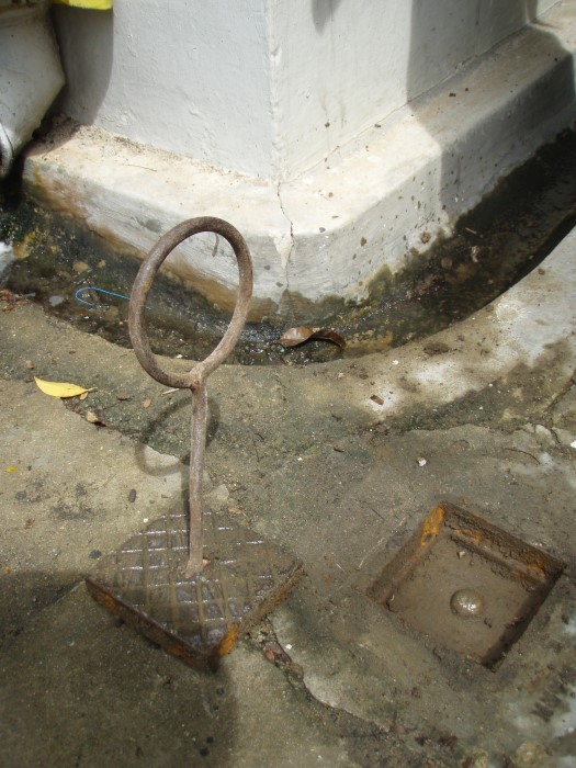 A benchmark at the pump house of MacRitchie Reservoir, installed in 1960.
This benchmark is still in use today for precise levelling. The top of the
bolt has a height elevation value. This information, which may also be
purchased online via the Singapore Land Authority portal, is used by civil
contractors to determine the surface elevation of the area. Image courtesy of
Singapore Land Authority
A benchmark at the pump house of MacRitchie Reservoir, installed in 1960.
This benchmark is still in use today for precise levelling. The top of the
bolt has a height elevation value. This information, which may also be
purchased online via the Singapore Land Authority portal, is used by civil
contractors to determine the surface elevation of the area. Image courtesy of
Singapore Land Authority
Modern-day Relevance of Benchmarks
As Singapore and the world confront the climate crisis, rising sea levels due to global warming pose a major threat to Singapore’s survival, being a low-lying island-state. Thirty percent of Singapore is less than five metres above the Singapore Height Datum, which means that any increase in sea level could spell disaster—coastal land may very well be swallowed by the sea.
The precise level benchmarks spread across the island today allow authorities to form a detailed terrain map used to assess the impact of rising sea levels on critical infrastructure. Low-lying areas that are more vulnerable to a rise in sea level may be raised, while other potentially risky areas may require mitigation strategies for localised flash floods.
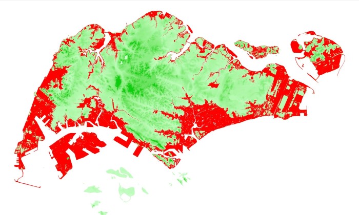 Coastal low-lying areas in Singapore (in red) are highly susceptible to
rising sea levels brought about by the climate crisis. Image courtesy of
Singapore Land Authority
Coastal low-lying areas in Singapore (in red) are highly susceptible to
rising sea levels brought about by the climate crisis. Image courtesy of
Singapore Land Authority
Benchmarks also serve another significant function: a well-distributed and accurately surveyed precise levelling network ensures the safety of a wide range of engineering projects, both above and underground. These include the construction of expressways, train tunnels and airport terminals, among others.
Often unnoticed, unseen, benchmarks are visually unspectacular objects that are embedded in our everyday vernacular environment.5 But belying their nondescript appearance and modest size, they, too, have a story to tell and serve a very important function as Singapore continues to transform and adapt its land use according to market conditions, government policies and the climate crisis. We simply need to pay attention to our surroundings as the city reveals its layers to us with all its marks and traces.
Notes
1 Italo Calvino, Invisible Cities (New York: Harcourt Bruce Jovanovich, 1978), 11.
2 The mean sea level is derived from the sea level between high tides and low tides.
3 It is speculated that the Cavenagh Bridge benchmark as shown in the 1881 map was selected to be the reference datum in 1882 when the mean sea level was determined. It is a common practice among land surveyors to select a single pre-established benchmark for use as a reference (datum) for future surveys out of convenience and cost considerations. It is expensive to start every levelling survey from the tide gauge onwards.
4 The existence of these two benchmarks has not yet been verified by SLA.
5 Benchmarks are typically located in unobtrusive spots and hidden from the public eye to ensure their permanence and stability.